
Page 324 - Moving the Earth_ The Workbook of Excavation
P. 324
LANDSCAPING AND AGRICULTURAL GRADING
7.18 THE WORK
Bench Terraces. The principal application of bench terraces in the United States is in connection
with irrigation. If the original slope of the land is greater than that of the graded fields, each field
will constitute a terrace, separated from fields above and below by comparatively steep slopes.
Benches may also be made in steep cultivated land by leaving narrow contour strips in grass
or other permanent vegetation. Soil washing from the wider strips between will be caught by the
grass and will tend to build up the low side of the cultivated piece, while its top is lowered by ero-
sion. This process, often accelerated by plowing so as to throw dirt downhill, will ultimately result
in gentle slopes separated by steep banks.
This work is ordinarily done by farmers without assistance from contractors.
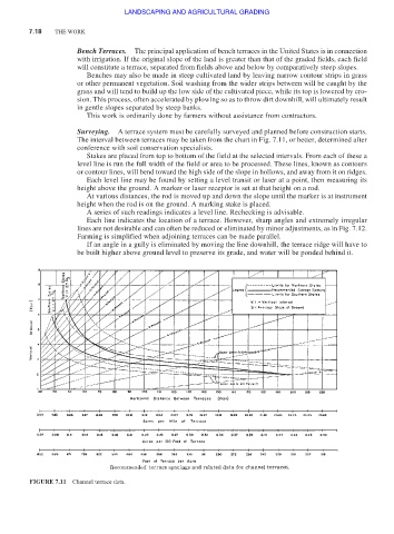
Surveying. A terrace system must be carefully surveyed and planned before construction starts.
The interval between terraces may be taken from the chart in Fig. 7.11, or better, determined after
conference with soil conservation specialists.
Stakes are placed from top to bottom of the field at the selected intervals. From each of these a
level line is run the full width of the field or area to be processed. These lines, known as contours
or contour lines, will bend toward the high side of the slope in hollows, and away from it on ridges.
Each level line may be found by setting a level transit or laser at a point, then measuring its
height above the ground. A marker or laser receptor is set at that height on a rod.
At various distances, the rod is moved up and down the slope until the marker is at instrument
height when the rod is on the ground. A marking stake is placed.
A series of such readings indicates a level line. Rechecking is advisable.
Each line indicates the location of a terrace. However, sharp angles and extremely irregular
lines are not desirable and can often be reduced or eliminated by minor adjustments, as in Fig. 7.12.
Farming is simplified when adjoining terraces can be made parallel.
If an angle in a gully is eliminated by moving the line downhill, the terrace ridge will have to
be built higher above ground level to preserve its grade, and water will be ponded behind it.
FIGURE 7.11 Channel terrace data.