
Page 35 - An Atlas of Carboniferous Basin Evolution in Northern England
P. 35
20 Chapter 3
carbonates, with no late Asbian or Brigantian strata present (Evans & Kirby
1999). Non-deposition or erosion is interpreted on the crest of the high in late
Dinantian to early Namurian times, prior to overstepping by Edale Shales in
the Kinderscoutian (Evans & Kirby 1999). The Eyam borehole (Strank, 1985)
provides important control on the Dinantian stratigraphy on the southern
footwall of the basin. The nearest Dinantian outcrop to the Edale Gulf is the
Derbyshire carbonate platform, whose northern margin is exposed a few
kilometres to the west of the regional seismic profile at Castleton. The
evolution of the basin margin fades during the late Dinantian provides the
context in which to evaluate the tcctono-stratigraphic development of the
Edale Gulf.
Sediments older than EC2 are interpreted to lie at the base of the Edale Gulf
by analogy with similar basins in northern England and the presence of EC1
continental fades in the Eyam borehole on the footwall of the gulf (Fig. 17).
Carbonate buildups developed on the northern margin in the Chadian early
Holkerian (EC2). During the Arundian to early Asbian (EC3/EC4), deposition
within the Edale Gulf was on a carbonate ramp/rimmed shelf, prograding
southwards from the Holme High towards the Derbyshire carbonate platform
(Evans & Kirby 1999). Deposition in the basin was mainly of resedimented
shallow water carbonates shed from the southern footwall and northern
dipslope, together with basinal shales and volcaniclastic sediments.
During the Asbian (EC4), the Derbyshire carbonate platform was fringed to
the north by a high angle margin with depositional dips of up to 30 towards the
basin (Stevenson & Gaunt 1971, Broadhurst & Simpson 1967, 1973). In the late
Asbian and early Brigantian (EC5) a complex of coarse bioclastic grainstone
shoals developed in association with the platform margin (Eden et al. 1964,
Stevenson & Gaunt 1971). These shoals comprise stacked large-scale bedforms
that prograded basinward in response to a rise in sea-level of some 20-25 m at
the onset of EC5 rifting (Gawthorpe & Gutteridge 1990). The presence of an
angular unconformity in the late Asbian-early Brigantian of the Alport
borehole suggests that the southern bounding fault of the Edale Gulf was
active during EC5 rifting. In contrast, the northern margin of the basin and the
immediate footwall of the Holme High became a site of non-deposition in late
Dinantian times (Evans & Kirby 1999).
At the base of Winnat's Pass near Castleton, the Beach Beds form a
distinctive unit of coarse turbiditic bioclastic grainstone onlapping the Asbian
foreslope (Eden et al 1964; Stevenson & Gaunt 1971, Sadler 1964). Evidence
from the Castleton borehole shows that the Beach Beds interfinger with and are
overlain by basinal sediments. The stratigraphic position of the Beach Beds
suggests that they may be basinal equivalents of the late Asbian-early
Brigantian (EC5) shelf margin grainstone shoals. The Derbyshire carbonate
platform was finally onlapped in the late Brigantian-early Namurian (LC1a)
by basinal sediments consisting of pro-delta Edale Shales, and the basin was
subsequently infilled by deposits of the Kinderscout and subsequent deltas
(LClb&c).
Bowland/Craven Basin
The Bowland/Craven Basin (hereafter referred to as the Bowland Basin)
comprises a major NE-SW-trending Dinantian half graben (Figs 10 and 18).
The basin underwent intense folding and uplift during the late Carboniferous
Variscan inversion such that sediments of Courceyan age (EC1) are exposed at
surface along the axis of the basin (Fig. 18). More than 4 km of Dinantian
sediments are indicated from the seismo-stratigraphic interpretation (Fig. 18)
and gravity modelling (Lee 1988, Corfield et al. 1996). This contrasts with
500 m of shallow water carbonates proven by the Holme Chapel borehole on
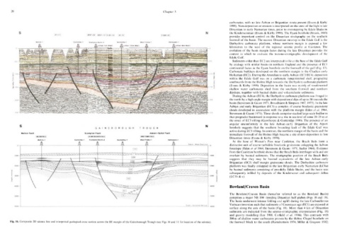
Fig. 16. Composite 2D seismic line and interpreted geological cross section across the SE margin of the Gainsborough Trough (see Figs 10 and 11 for location of the seismic). the footwall block to the south (Ramsbottom 1974; Miller & Grayson 1982;