
Page 58 - An Atlas of Carboniferous Basin Evolution in Northern England
P. 58
and
Palaeogeography
platforms
fringing the footwall of
the crest of the fault block, whereas the Holme High became a drowned, this basin (Fig. 30). To the SE, the carbonate fades evolution 37
sediment-starved high (Evans & Kirby 1999). the Pendle fault finally drowned (Evans & Kirby 1999). Further north, cyclic
Gutteridge (1987) identifies two periods of emergence and karstic erosion on Yoredale sedimentation continued in Stainmore and across the Alston and
the Derbyshire Dome in the late Asbian and early Brigantian. These may Askrigg Blocks (Fig. 30).
correspond to two pulses of extension in the area during EC5 times, leading to The onset of siliciclastic turbidite deposition in the Bowland and Cleveland
footwall uplift and erosion. In the Widmerpool Gulf, carbonate production Basins marks a major change in depositional style in the central Pennines and
ceased either as the EC5 transgression inundated the shelf margins (hanging- East Midlands which continued into the early part of the post-rift
wall setting) or the marginal platforms became emergent (footwall setting). megasequence. In all of these areas, the first major siliciclastic-dominated
In Stainmore and on the Alston and Askrigg Blocks, where shallower water sequences contain prominent turbidites reflecting the influence of local
conditions prevailed close to the clastic source, cyclic Yoredale sedimentation antecedent syn-rift bathymetry and sediment bypass on sequence development
was dominant (Johnson 1960) (Fig. 29). The Yoredale cycles can be interpreted (Fig. 31).
as high-frequency depositional sequences. The marine limestones within the
cycles are the equivalent of condensed sections associated with maximum
flooding surfaces, formed when the rate of relative sea-level rise outpaced Post-rift megasequence
clastic sediment supply. The overlying coarsening and shoaling upward fluvio-
deltaic units are highstand systems tracts, with local erosionally based, The post-rift megasequence can be divided into two tectono-stratigraphic
multistorey fluvial sandstones representing lowstand incised valley fills. As with sequences, LCI and LC2. The boundary between these two tectono-
the depositional sequences developed on the carbonate platforms further stratigraphic sequences represents a major change from lower to upper delta-
south, transgressive systems tracts are thin. The regional extent of the Yoredale plain environments throughout most of northern England. Seismic data show
cycles suggests a glacio-eustatic control; however, Leeder & Strudwick (1987) the post-rift megasequence to have been deposited regionally across northern
also highlight the role of local tectonics and sediment supply. England (e.g. Fig. 12). Isopachs for the post-rift section exhibit a classic
Rifting in EC5 is also associated with renewed igneous activity. In bullseye pattern interpreted by Leeder (1982) as resulting from a phase of
Derbyshire this phase of igneous activity is represented by the Lower and passive thermal subsidence (Fig. 32). A similar thermal sag has been identified
Upper Millers Dale Lavas (Walkden 1977, Walters & Ineson 1981, Macdonald further east in the Southern North Sea (Leeder & Hardman, 1990).
et al 1984). In the East Midlands, basalts and tuffs in Strelley-1 (Fig. 14) are During the early part of the post-rift megasequence, sediment supply
associated with a series of NW-SE-trending faults, the Cinderhill Fault, which overtook subsidence for the first time, allowing marked southward prograda-
bounds the northern margin of the Widmerpool Gulf (e.g. Fraser & tion of the fluvio-deltaic system and the infill of the remnant rift topography
Gawthorpe 1990) (Fig. 29). with deltaic sediments (Fig. 31). Backstripping of the top syn-rift reflector in
the Widmerpool Gulf indicates water depths of around 300 m for the sediment
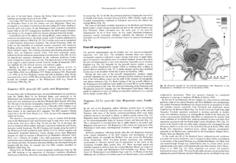
starved half graben at this time. The observed thickening of the Namurian and Fig. 32. Restored isopachs for the post-rift megasequence (late Brigantian to late
Sequence EC6: post-rift III (early-mid Brigantian) Westphalian (post-rift) isopachs into the Widmerpool Gulf (Kent 1966) can Westphalian C). Modified from Fraser & Gawthorpe (1990).
partly be explained in terms of infilling of antecedent bathymetry in a starved
It seems likely that, by Brigantian times, basinal sedimentation was continuous rift by deltaic systems (Fig. 32). southeasterly provenance. These low sinuosity channels are considered
from the Dublin Basin to the Bowland Basin, and eastwards to the analogous to outcrops in Anglesey (Walkden & Davies 1983).
Widmerpool and Gainsborough basins (Fig. 30). In contrast, shelf limestone By the end of the Dinantian, the last vestiges of a once-extensive carbonate
facies were now widespread across the East Midlands Shelf (Strank 1987) (Fig. Sequence LCla: post-rift (late Brigantian-early Pendle- platform south of the central Pennines and East Midlands were disappearing.
30). The top of the tectono-stratigraphic sequence EC6 is well constrained by ian) The earliest Namurian (Pendleian) was characterized by progradation of delta
the top of the G. bilineatus conodont Zone of Metcalfe (1981) (Ebdon et al. and turbidite systems westwards from Cleveland and southwards across
1990). Conodont assemblages are rich and diverse throughout and resemble By the end of the Brigantian, deltaic influence covered most of northern Cumbria into the Bowland Basin (Fig. 33). North of Craven Fault Zone, high
those present in the underlying EC5 sequence. The EC6 sequence belongs England and the carbonate platforms were restricted to south of the central frequency Yoredale sequences continued to develop, generally in shallow
exclusively to the NC Zone (Neves et al 1972), the top of the sequence falling Pennines, with most of the former carbonate-producing shelf areas being water, low subsidence settings (e.g. Askrigg Block). South of the fault zone, the
within the biozone. sediment starved or drowned by deltaic or shallow marine elastics (Fig. 33). earliest coarse-grained siliciclastic deposition is represented by stacked deep
The interval is characterized by carbonate ramp to rimmed shelf develop- Brigantian strata belonging to sequences EC6 and LCla are not encountered water turbidites of the Pendle Grit, marking sediment by-pass and basin floor
ment in the Widmerpool Gulf and Gainsborough Trough where water depths on the palaeotopographic highs of Nocton, Foston and Stixwold (Fig. 33). deposition associated with the Pendle delta system (Martinsen 1993; Fig. 33).
in the basins were up to 300 m (Fig. 30; also see Fig. 12). In the basin this This is interpreted as non-deposition due to uplift related to the earlier mid- South of the Pendle Fault, pro-delta shales onlapped and overstepped the late
interval comprises thinly bedded, dark grey, calcareous mudstones and brown, Brigantian inversion event. The Brigantian is also absent over large parts of the Dinantian platform on the crest of the fault block (Evans & Kirby 1999). After
dolomitic muddy limestones. The EC6 hanging-wall margin along the north of Widmerpool Gulf where mid-Brigantian inversion is thought to have been Pendle Grit deposition, shallower-water, deltaic deposits accumulated,
the Widmerpool Gulf established itself shelfward of the Asbian margins and strongest. especially in the Skipton area, represented by the Grassington, Skipton Moor,
subsequently prograded basinward. Facies changes across these Brigantian Renewed subsidence, following shortly after the mid Brigantian inversion Warley Wise and Beamsley Grits.
margins are rapid as exposed at Wirksworth in Derbyshire (Walkden 1982). event, caused inundation of the shelf margins and development of new To the south and SE of the Bowland Basin, sediment-starved conditions
Here, over a distance of roughly 1 km, shelf grainstones, packstones and intrashelf basins, for example the Welbeck Low and across the Derbyshire prevailed and basinal mudstones, rich in terrigenous plant debris, accumulated
wackestones pass southwards through stacked grainstone shoal complexes and Dome (Gutteridge 1987). Pro-delta basinal mudstones and turbidites in sub-basins of the central Pennines (e.g. Huddersfield Basin), the Edale Gulf
into slumps and slides. Prominent carbonate buildups also developed along the accumulated in inherited starved syn-rift depocentres to the south of the and Gainsborough Trough (e.g. Edale Shales) and, to a lesser extent, across
hanging-wall dip slope, for example the Coal Hills complex described by advancing Yoredale delta system (Fig. 33). More proximal quartz-rich depositionally lower parts of the Humberside area (thin Gamma Active Shales,
Walkden (1982) (Fig. 30). turbidite sandstones derived from the London-Brabant Massif are evident in Fraser et al. 1990; Fig. 33). These mudstones are proven rich potential
During EC6, the Pendle delta system prograded southwards from the NE several Goyt Trough and Widmerpool Gulf boreholes (e.g. Bosley, Nooks hydrocarbon source rocks. The main Pendle delta advance was prevented from
and NW resulting in the deposition of siliciclastic turbidites (Pendleside Farm-1 A, Widmerpool-1 and Duffield; Figs 2 and 33). At Welton in the East entering the central Pennines and East Midlands area by the Pendle Fault with
Sandstone) in Bowland, effectively precluding further carbonate production in Midlands, the top Dinantian includes quartzose channel sands, with a probable