
Page 209 - Biosystems Engineering
P. 209
GIS-Based W atershed Modeling Systems 187
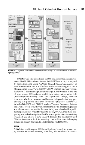
Nationally available data Assessment tools Models
Base
cartographic Target HSPF
data
GenSen Decision-making
Environmental analysis
background data
Environmental
monitoring data Swat
Assess
GenSen
Watershed
Data mining Qualze management
Point source/loadings data •
TMDLs
•
Source water
protection
Watershed reporting Pload •
Stormwater
User supplied User supplied User supplied
data tools models
FIGURE 5.2 System overview of BASINS Version 3.0 (U.S. Environmental Protection
Agency 2001).
BASINS was first introduced in 1996 and since then several ver-
sions of BASINS have been released. BASINS Version 1.0, 2.0, 3.0, and
3.1 were developed using ArcView 2.X and 3.X environments. The
simulation models run in a Windows environment using data input
files generated in ArcView. In 2007, USEPA released a newer version,
BASINS 4.0. The most significant change in this version is the use
of open-source GIS software architecture using Mapwindow GIS
(www.mapwindow.com). With this significant change, BASINS
became available to everyone and became independent of any pro-
prietary GIS platform and open for useful “plug-ins.” BASINS 4.0
includes WinHSPF and PLOAD models. The new Parameter Estima-
tion (PEST) tool in WinHSPF automates the model calibration process
and allows users to quantify the uncertainty associated with specific
model predictions. WinHSPF links to the AQUATOX model for inte-
grating watershed analysis with effects on aquatic biota in receiving
waters. It also allows a new BASINS feature, the Windows-based
Climate Assessment Tool, for assessing potential impacts of changing
climate on stream flows and pollutant loads (USEPA 2008).
AGWA
AGWA is a multipurpose GIS-based hydrologic analysis system use
by watershed, water resource, land use, and biological resources