
Page 171 - Caldera Volcanism Analysis, Modelling and Response
P. 171
146 Gerardo J. Aguirre-Dı ´az et al.
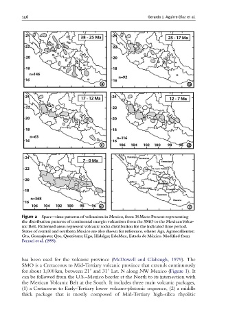
Figure 2 Space--time patterns of volcanism in Mexico, from 38 Ma to Present representing
the distribution patterns of continental margin volcanism from the SMO to the MexicanVolca-
nic Belt. Patterned areas represent volcanic rocks distribution for the indicated time period.
States of central and southern Mexico are also shown for reference, where: Ags, Aguascalientes;
Gto, Guanajuato; Qro, Quere ¤ taro; Hgo, Hidalgo; EdoMex, Estado de Me ¤ xico. Modi¢ed from
Ferrari et al. (1999).
has been used for the volcanic province (McDowell and Clabaugh, 1979). The
SMO is a Cretaceous to Mid-Tertiary volcanic province that extends continuously
for about 1,000 km, between 211 and 311 Lat. N along NW Mexico (Figure 1). It
can be followed from the U.S.–Mexico border at the North to its intersection with
the Mexican Volcanic Belt at the South. It includes three main volcanic packages,
(1) a Cretaceous to Early-Tertiary lower volcano-plutonic sequence, (2) a middle
thick package that is mostly composed of Mid-Tertiary high-silica rhyolitic