
Page 182 - Caldera Volcanism Analysis, Modelling and Response
P. 182
The Sierra Madre Occidental, Mexico 157
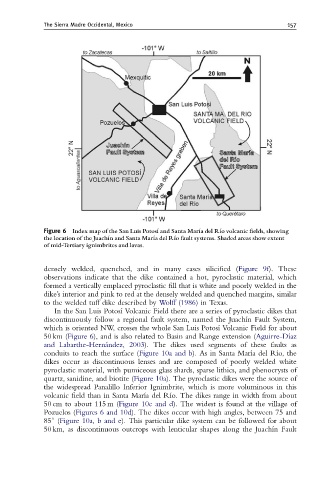
Figure 6 Index map of the San Luis Potos|¤ and Santa Mar|¤adel R|¤o volcanic ¢elds, showing
the location of the Juach|¤ n and Santa Mar|¤adel R|¤o fault systems. Shaded areas show extent
of mid-Tertiary ignimbrites and lavas.
densely welded, quenched, and in many cases silicified (Figure 9f). These
observations indicate that the dike contained a hot, pyroclastic material, which
formed a vertically emplaced pyroclastic fill that is white and poorly welded in the
dike’s interior and pink to red at the densely welded and quenched margins, similar
to the welded tuff dike described by Wolff (1986) in Texas.
In the San Luis Potosı ´ Volcanic Field there are a series of pyroclastic dikes that
discontinuously follow a regional fault system, named the Juachı ´n Fault System,
which is oriented NW, crosses the whole San Luis Potosı ´ Volcanic Field for about
50 km (Figure 6), and is also related to Basin and Range extension (Aguirre-Dı ´az
and Labarthe-Herna ´ndez, 2003). The dikes used segments of these faults as
conduits to reach the surface (Figure 10a and b). As in Santa Marı ´a del Rı ´o, the
dikes occur as discontinuous lenses and are composed of poorly welded white
pyroclastic material, with pumiceous glass shards, sparse lithics, and phenocrysts of
quartz, sanidine, and biotite (Figure 10a). The pyroclastic dikes were the source of
the widespread Panalillo Inferior Ignimbrite, which is more voluminous in this
volcanic field than in Santa Marı ´a del Rı ´o. The dikes range in width from about
50 cm to about 115 m (Figure 10c and d). The widest is found at the village of
Pozuelos (Figures 6 and 10d). The dikes occur with high angles, between 75 and
851 (Figure 10a, b and e). This particular dike system can be followed for about
50 km, as discontinuous outcrops with lenticular shapes along the Juachı ´n Fault