
Page 49 - Carbonate Facies in Geologic History
P. 49
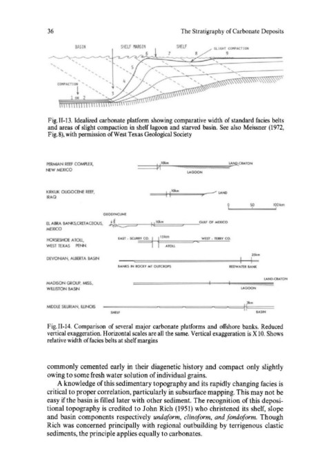
36                                     The Stratigraphy of Carbonate Deposits

                       BASIN        SHElf  IlARGI N   SHELf    SL 1 GHl  COitPAC TI ""
                                           6                       9

                   ......                           ...  ...


               Fig.II-l3. Idealized carbonate platform showing comparative width of standard facies  belts
               and areas  of slight compaction in shelf lagoon and starved basin.  See  also  Meissner (1972,
               Fig. 8), with permission of West Texas Geological Society


               PBMIAN REEf  COMPlEx.     =--------=PI==:M-1OO'---·---....lJ""..,m"n.""mm,m"""''''''mllJlllmlliiu;mnnrmmmu;;m,Mim;m~~.-1tClATOH
              i'l:W MEXICO                              LAGOON


              KlRI(lJI( OUGOC.ENE REEf.      =="'1 ~11,;,;Olu=.=~.." .... _____  LAND
               IRAQ
                                                                   o 1.1 __ ...... 1 ____
                                                                                 1
                                                                                 IOOkm
                                                                          ~
                               GEOSYNCLINE
              a .... BRA  BAI«S,CRET .... CEOUS,
              MEXICO
               HORSESHOe .... Tou.                        c   WEST  •  TIDY CO
               WEST  TEXAS   PENN
               DEVONIAN, AI.6ERTA  BASIN
                                                                    lfOWAIU lANK
                                                                              lAND.cv.TON
               MADISON GROUP, MISS.     ====~~~======~~-~~jjj~;;;"";;h""m""'m""m""m""'m""~m#,
               WWSTON  BAS1'4                                          LAGOON


               MDOlE StURIAN, UN:)IS

               Fig.II-14.  Comparison  of several  major carbonate platforms  and  offshore  banks.  Reduced
               vertical exaggeration. Horizontal scales are all the same. Vertical exaggeration is X 10. Shows
               relative width of facies belts at shelf margins


               commonly cemented early in  their diagenetic history and compact only slightly
               owing to some fresh water solution of individual grains.
                  A knowledge of this sedimentary topography and its rapidly changing facies is
               critical to proper correlation, particularly in subsurface mapping. This may not be
               easy if the basin is filled later with other sediment. The recognition of this deposi-
               tional topography is credited to John Rich (1951)  who christened its shelf, slope
               and basin components respectively  undafarm,  dinafarm,  and fandafarm.  Though
               Rich was  concerned principally with regional  outbuilding by  terrigenous  clastic
               sediments, the principle applies equally to carbonates.