
Page 232 - Carbonate Platforms Facies, Sequences, and Evolution
P. 232
by
Fig.
upper
cavities,
up
platform margin.
to
Palorbitolina
Orbitolina
beds.
surface of the Urgonian
others are karstic cavities.
limestone
1m across,
In
are
Finally,
similar
platform in
to
large
that
rootmolds,
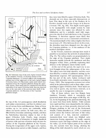
Urgonian platform. (A) Direction of the Urgonian
in the northern Vercors. (1) Erosion surface of the
only on the outer part of the previous inner-shelf of the
deposited above the Urgonian platform during the upper
and vadose cementation), and then by distinct cavi
Urgonian limestone; (2) incised valleys with transgressive
Orbitolina beds); (3) Glauconitic sandy marls which were
systems tract of the upper part of the early Aptian (upper
equivalent of the upper Orbitolina beds; they are observed
the Vercors.
early Aptian. These marls may be considered as the lateral
During the trangression of the upper early Aptian,
the top of the Ai2 parasequence (shell dissolution
13. Schematic map of the early Aptian incised valleys
of the
both cases, they are
while
filled first by limestone containing crinoids, and then
these depressions served as tidal channels, and then
of metres wide and tens of metres deep cut into the
ties of various forms and dimensions. Some of these
depressions, tens of kilometres in length, hundreds
extensive
to
the
and
least
rise,
be
One
the top
currents
Pelagian
sea must
the
edge
(northern
30m
limestone.
of
lithification
(numerous
part
It
consists
since
section covers
decimetre-thick
and
deep
of
of the
disappear within
these
The Jura and northern Subal pine chains
of
currents
platform
in
boring
this
by
incompatible
a
the
Vercors),
to
a
level
therefore
20 km,
were
with
valleys,
the
northern Subalpine chains.
region
thin,
early
Urgonian
the case
which
less
which
of
the bottom and
east
organisms).
probably
near
was
is
appears
simple
It
Aptian
of
was
have been fairly shallow.
Les
iron-rich
strong,
platform.
small
more
the
affected
decreases rapidly towards the northwest
erosion
locally
usually the case in transgressive sediments.
tidal
Their
the Rochers
lithified
by
by
Rimets
remarkably
absence in the Subalpine chains farther north.
likely
( deshayesi
allowing
very rich in quartz, clay and heavy minerals, as
solely in the palaeovalleys and on their edges, corre
centimetre
At the end of this period, the rapid rise in sea
these valleys were cut in a continental environment.
channels are very deep, especially downcurrent, at
they were later filled by upper Orbitolina beds. The
de Ia
early
range,
level brought about the submergence of the area.
217
given the dearth of intertidal facies in the Urgonian
tidal
(Arnaud, 1981, fig. 281). This depth would appear
Ferriere channel north of the Gorges de Ia Bourne
that
was at least a 30-40 m fall in sea-level. In this event,
Tidal currents
preserved, shows three main stages of fill (Fig. 14).
probably explaining their
were rapid and they were channelled by the valleys,
and they
and
The maximum depth of the valleys implies that there
bowerbanki ammonite zones, zonation according to
sponding to upper Orbitolina beds. These marls are
Casey, 1961). The transgressive systems tract exists
possible to reconstruct the network of palaeovalleys
(Fig. 13). The valleys mostly run perpendicularly to
In the Vercors, numerous outcrops have made it
the Urgonian platform, i.e. to the southeast of the
depositional sequence AP2 (parasequence Ai3) at
is
The valleys were first tidal channels, and they were
farm
the
the shoreline must have dropped over the edge of
filling of the tidal channels by marls which are very
depth
well
(1) At the beginning of the platform drowning, the
the valley. (2) At the highest point of the sea-level
Kerkennah
Islands, Tunisia (Burollet et al., 1979). A condensed
early
in the same way as those presently observed on the
contains
then filled by a variety of sediments making up the
numerous corals and large rudistids on the edge of
sides of this valley