
Page 232 - Forensic Structural Engineering Handbook
P. 232
7.16 CAUSES OF FAILURES
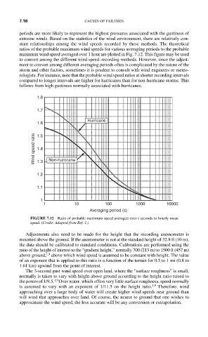
periods are more likely to represent the highest pressures associated with the gustiness of
extreme winds. Based on the statistics of the wind environment, there are relatively con-
stant relationships among the wind speeds recorded by these methods. The theoretical
ratios of the probable maximum wind speeds for various averaging periods to the probable
maximum wind speed averaged over 1 hour are plotted in Fig. 7.12. This figure may be used
to convert among the different wind speed–recording methods. However, since the adjust-
ment to convert among different averaging periods often is complicated by the nature of the
storm and other factors, sometimes it is prudent to consult with wind engineers or meteo-
rologists. For instance, note that the probable wind speed ratios at shorter recording intervals
compared to longer intervals are higher for hurricanes than for non-hurricane storms. This
follows from high gustiness normally associated with hurricanes.
1.8
1.7
Hurricane
1.6
Wind speed ratio 1.4 Non-hurricane
1.5
1.3
1.2
1.1
1
1 10 100 1000 10000
Averaging period (s)
FIGURE 7.12 Ratio of probable maximum speed averaged over t seconds to hourly mean
speed. (Credit: Adapted from Ref. 1.)
Adjustments also need to be made for the height that the recording anemometer is
mounted above the ground. If the anemometer is not at the standard height of 32.8 ft (10 m),
the data should be calibrated to standard conditions. Calibrations are performed using the
ratio of the height of interest to the “gradient height,” normally 700 (213 m) to 1500 ft (457 m)
above ground, 1,9 above which wind speed is assumed to be constant with height. The value
of an exponent that is applied to this ratio is a function of the terrain for 0.5 to 1 mi (0.8 to
1.61 km) upwind from the point of interest.
The 3-second gust wind speed over open land, where the “surface roughness” is small,
normally is taken to vary with height above ground according to the height ratio raised to
1,9
the power of 1/9.5. Over water, which offers very little surface roughness, speed normally
is assumed to vary with an exponent of 1/11.5 on the height ratio. 1,9 Therefore, wind
approaching over a large body of water will create higher wind speeds near ground than
will wind that approaches over land. Of course, the nearer to ground that one wishes to
approximate the wind speed, the less accurate will be any conversion or extrapolation.