
Page 244 - Fundamentals of Geomorphology
P. 244
FLUVIAL LANDSCAPES 227
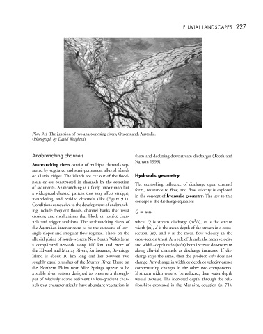
Plate 9.4 The junction of two anastomosing rivers, Queensland, Australia.
(Photograph by David Knighton)
Anabranching channels them and declining downstream discharges (Tooth and
Nanson 1999).
Anabranching rivers consist of multiple channels sep-
arated by vegetated and semi-permanent alluvial islands
or alluvial ridges. The islands are cut out of the flood- Hydraulic geometry
plain or are constructed in channels by the accretion The controlling influence of discharge upon channel
of sediments. Anabranching is a fairly uncommon but form, resistance to flow, and flow velocity is explored
a widespread channel pattern that may affect straight, in the concept of hydraulic geometry. The key to this
meandering, and braided channels alike (Figure 9.1). concept is the discharge equation:
Conditions conducive to the development of anabranch-
ing include frequent floods, channel banks that resist Q = wdv
erosion, and mechanisms that block or restrict chan-
3
nels and trigger avulsions. The anabranching rivers of where Q is stream discharge (m /s), w is the stream
the Australian interior seem to be the outcome of low- width (m), d is the mean depth of the stream in a cross-
angle slopes and irregular flow regimes. Those on the section (m), and v is the mean flow velocity in the
alluvial plains of south-western New South Wales form cross-section (m/s). As a rule of thumb, the mean velocity
a complicated network along 100 km and more of and width–depth ratio (w/d) both increase downstream
the Edward and Murray Rivers; for instance, Beveridge along alluvial channels as discharge increases. If dis-
Island is about 10 km long and lies between two charge stays the same, then the product wdv does not
roughly equal branches of the Murray River. Those on change. Any change in width or depth or velocity causes
the Northern Plains near Alice Springs appear to be compensating changes in the other two components.
a stable river pattern designed to preserve a through- If stream width were to be reduced, then water depth
put of relatively coarse sediment in low-gradient chan- would increase. The increased depth, through the rela-
nels that characteristically have abundant vegetation in tionships expressed in the Manning equation (p. 71),