
Page 264 - Fundamentals of Geomorphology
P. 264
GLACIAL AND GLACIOFLUVIAL LANDSCAPES 247
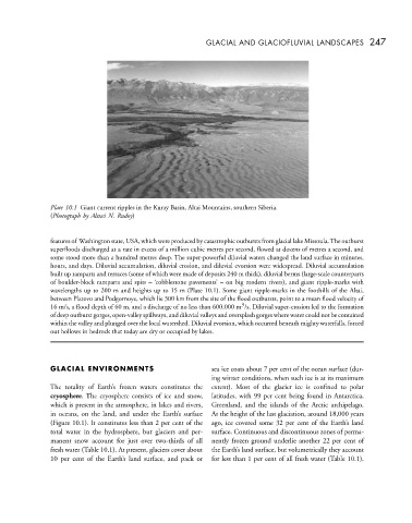
Plate 10.1 Giant current ripples in the Kuray Basin, Altai Mountains, southern Siberia.
(Photograph by Alexei N. Rudoy)
features of Washington state, USA, which were produced by catastrophic outbursts from glacial lake Missoula.The outburst
superfloods discharged at a rate in excess of a million cubic metres per second, flowed at dozens of metres a second, and
some stood more than a hundred metres deep. The super-powerful diluvial waters changed the land surface in minutes,
hours, and days. Diluvial accumulation, diluvial erosion, and diluvial evorsion were widespread. Diluvial accumulation
built up ramparts and terraces (some of which were made of deposits 240 m thick), diluvial berms (large-scale counterparts
of boulder-block ramparts and spits – ‘cobblestone pavements’ – on big modern rivers), and giant ripple-marks with
wavelengths up to 200 m and heights up to 15 m (Plate 10.1). Some giant ripple-marks in the foothills of the Altai,
between Platovo and Podgornoye, which lie 300 km from the site of the flood outbursts, point to a mean flood velocity of
3
16 m/s, a flood depth of 60 m, and a discharge of no less than 600,000 m /s. Diluvial super-erosion led to the formation
of deep outburst gorges, open-valley spillways, and diluvial valleys and oversplash gorges where water could not be contained
within the valley and plunged over the local watershed. Diluvial evorsion, which occurred beneath mighty waterfalls, forced
out hollows in bedrock that today are dry or occupied by lakes.
GLACIAL ENVIRONMENTS sea ice coats about 7 per cent of the ocean surface (dur-
ing winter conditions, when such ice is at its maximum
The totality of Earth’s frozen waters constitutes the extent). Most of the glacier ice is confined to polar
cryosphere. The cryosphere consists of ice and snow, latitudes, with 99 per cent being found in Antarctica,
which is present in the atmosphere, in lakes and rivers, Greenland, and the islands of the Arctic archipelago.
in oceans, on the land, and under the Earth’s surface At the height of the last glaciation, around 18,000 years
(Figure 10.1). It constitutes less than 2 per cent of the ago, ice covered some 32 per cent of the Earth’s land
total water in the hydrosphere, but glaciers and per- surface. Continuous and discontinuous zones of perma-
manent snow account for just over two-thirds of all nently frozen ground underlie another 22 per cent of
fresh water (Table 10.1). At present, glaciers cover about the Earth’s land surface, but volumetrically they account
10 per cent of the Earth’s land surface, and pack or for less than 1 per cent of all fresh water (Table 10.1).