
Page 11 - Geochemical Anomaly and Mineral Prospectivity Mapping in GIS
P. 11
6 Chapter 1
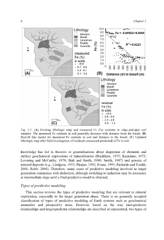
Fig. 1-1. (A) Existing lithologic map and measured Fe (%) contents in ridge-and-spur soil
samples. The measured Fe contents in soil generally decrease with distance from the basalt. (B)
Best-fit line model for measured Fe contents in soil and distance to the basalt. (C) Updated
lithologic map after field investigation of residuals (measured-predicted) of Fe in soil.
knowledge has led to theories or generalisations about dispersion of elements and
surface geochemical expressions of mineralisation (Bradshaw, 1975; Kauranne, 1975;
Lovering and McCarthy, 1978; Butt and Smith, 1980; Smith, 1987) and genesis of
mineral deposits (e.g., Lindgren, 1933; Pirajno, 1992; Evans, 1993; Richards and Tosdal,
2001; Robb, 2004). Therefore, many cases of predictive modeling involved in target
generation commence with deduction, although switching to induction may be necessary
at intermediate steps until a final predictive model is obtained.
Types of predictive modeling
This section reviews the types of predictive modeling that are relevant to mineral
exploration, especially in the target generation phase. There is no generally accepted
classification of types of predictive modeling of Earth systems such as geochemical
anomalies and prospective areas. However, based on the way inter-predictor
relationships and target-predictor relationships are described or represented, two types of