
Page 45 - Geochemical Remote Sensing of The Sub-Surface
P. 45
22 O.F. Putikov and B. Wen
B
C
x
ji~ Li ~ iiii iiii i iiiiiiiiii i i iliii"
!
i
I I l , I Zone 3 i iiiill !iilil i iiii!iiii
,_ ,.__~___~._~..__~__..~...~. . .
.
.
.
.
.
.
.
~ I [ IZone2
z i'.'!
................... -,.--i-----4
I !
........ ~ .... i .... ~ .... r ......... I I /
,
~
~
~
,
t_..~._.~__~.._~__i_.~.__~i, .......... ,i, ~
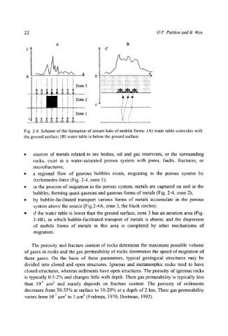
Fig. 2-4. Scheme of the formation of stream halo of mobile forms: (A) water table coincides with
the ground surface; (B) water table is below the ground surface.
9 sources of metals related to ore bodies, oil and gas reservoirs, or the surrounding
rocks, exist in a water-saturated porous system with pores, faults, fractures, or
microfractures;
9 a regional flow of gaseous bubbles exists, migrating in the porous system by
Archimedes force (Fig. 2-4, zone 1);
9 in the process of migration in the porous system, metals are captured on and in the
bubbles, forming quasi-gaseous and gaseous forms of metals (Fig. 2-4, zone 2);
9 by bubble-facilitated transport various forms of metals accumulate in the porous
system above the source (Fig.2-4A, zone 3, the black circles);
9 if the water table is lower than the ground surface, zone 3 has an aeration area (Fig.
2-4B), in which bubble-facilitated transport of metals is absent, and the dispersion
of mobile forms of metals in this area is completed by other mechanisms of
migration.
The porosity and fracture content of rocks determine the maximum possible volume
of gases in rocks and the gas permeability of rocks determines the speed of migration of
these gases. On the basis of these parameters, typical geological structures may be
divided into closed and open structures. Igneous and metamorphic rocks tend to have
closed structures, whereas sediments have open structures. The porosity of igneous rocks
is typically 0.5-2% and changes little with depth. Their gas permeability is typically less
than 10 .5 lam 2 and mainly depends on fracture content. The porosity of sediments
decreases from 30-35% at surface to 10-20% at a depth of 2 kin. Their gas permeability
varies from 10 .7 lam 2 to 3 l.tm 2 (Fridman, 1970; Dortman, 1992).