Page 261 - Geology of Carbonate Reservoirs
P. 261

242   SUMMARY: GEOLOGY OF CARBONATE RESERVOIRS


                                           -7000  -6850  -7050
                                                  -6750  SQC BHL -6950
                                                   -6700
                                                       SCM  -6850
                                                       BHL
                                               -6750           SQC 1A
                                                  -6650
                                          STQ 1
                                                        BHL
                                                  SCM 1       BT 1
                                                         BT     SUN
                                                         BHL
                                                                TABOR
                                             ST 1


                                                  Seismically Defined Structure:
                                                  Top of Meramec Formation
                                                  Quanah City Field, Texas

                             -6850

                                    GT 1

                             152


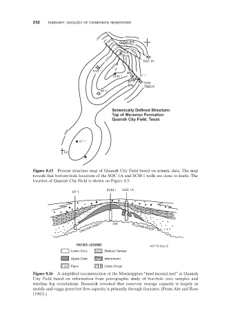
                    Figure 8.15   Present structure map of Quanah City Field based on seismic data. The map

               reveals that bottom - hole locations of the SQC 1A and SCM 1 wells are close to faults. The
               location of Quanah City Field is shown on Figure  8.5 .
                                                SCM 1  SQC 1A
                                ST 1


                                    UNCONFORMITY  ON       ELLENBURGER


                                  FACIES LEGEND
                                                                  NOT TO SCALE
                                Lower Core     Skeletal Veneer
                                Upper Core     Intermound
                                Flank          Oolite Shoal
                    Figure 8.16      A simplified reconstruction of the Mississippian  “ mud mound reef ”  at Quanah

               City Field based on information from petrographic study of borehole core samples and
               wireline log correlations. Research revealed that reservoir storage capacity is largely in

               moldic and vuggy pores but flow capacity is primarily through fractures. (From Ahr and Ross
               ( 1982 ).)
   256   257   258   259   260   261   262   263   264   265   266