
Page 116 - Geotechnical Engineering Soil and Foundation Principles and Practice
P. 116
The Soil Profile
The Soil Profile 111
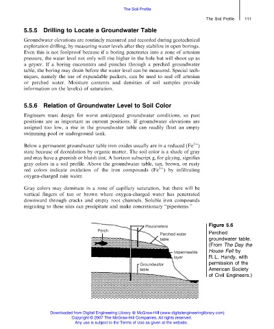
5.5.5 Drilling to Locate a Groundwater Table
Groundwater elevations are routinely measured and recorded during geotechnical
exploration drilling, by measuring water levels after they stabilize in open borings.
Even this is not foolproof because if a boring penetrates into a zone of artesian
pressure, the water level not only will rise higher in the hole but will shoot up as
a geyser. If a boring encounters and punches through a perched groundwater
table, the boring may drain before the water level can be measured. Special tech-
niques, namely the use of expandable packers, can be used to seal off artesian
or perched water. Moisture contents and densities of soil samples provide
information on the level(s) of saturation.
5.5.6 Relation of Groundwater Level to Soil Color
Engineers must design for worst anticipated groundwater conditions, so past
positions are as important as current positions. If groundwater elevations are
assigned too low, a rise in the groundwater table can readily float an empty
swimming pool or underground tank.
2þ
Below a permanent groundwater table iron oxides usually are in a reduced (Fe )
state because of deoxidation by organic matter. The soil color is a shade of gray
and may have a greenish or bluish tint. A horizon subscript g, for gleying, signifies
gray colors in a soil profile. Above the groundwater table, tan, brown, or rusty
3þ
red colors indicate oxidation of the iron compounds (Fe ) by infiltrating
oxygen-charged rain water.
Gray colors may dominate in a zone of capillary saturation, but there will be
vertical fingers of tan or brown where oxygen-charged water has penetrated
downward through cracks and empty root channels. Soluble iron compounds
migrating to these sites can precipitate and make concretionary ‘‘pipestems.’’
Figure 5.6
Perched
groundwater table.
(From The Day the
House Fell by
R. L. Handy, with
permission of the
American Society
of Civil Engineers.)
Downloaded from Digital Engineering Library @ McGraw-Hill (www.digitalengineeringlibrary.com)
Copyright © 2007 The McGraw-Hill Companies. All rights reserved.
Any use is subject to the Terms of Use as given at the website.