
Page 53 - Geotechnical Engineering Soil and Foundation Principles and Practice
P. 53
Special Problems with Sedimentary Rocks
48 Geotechnical Engineering
grouting, and it is not unusual for the volume of grout pumped to exceed the
volume of the dam itself. Also, groundwater flow through underground channels
can wash away the grout as it is injected, in which case asphalt or fibrous
materials may be added to try and seal things off. Experience indicates that the
prognosis for success is marginal.
Repair of Clay Pockets and Sinks
Clay pockets or sinks encountered at a building site can be dug out and filled with
rubble and concrete, or if they are too deep, bridged over. Rubble or broken
concrete is grouted to make a solid plug, or the sink can be bridged by steel mesh
or girders that support rubble fill that then is grouted. The grouted mass should be
bowl-shaped to prevent sinking into the sink.
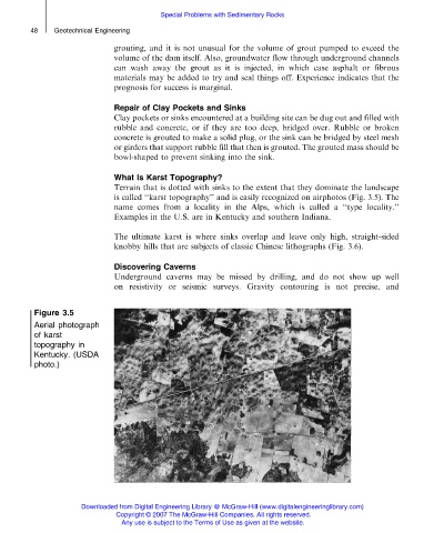
What Is Karst Topography?
Terrain that is dotted with sinks to the extent that they dominate the landscape
is called ‘‘karst topography’’ and is easily recognized on airphotos (Fig. 3.5). The
name comes from a locality in the Alps, which is called a ‘‘type locality.’’
Examples in the U.S. are in Kentucky and southern Indiana.
The ultimate karst is where sinks overlap and leave only high, straight-sided
knobby hills that are subjects of classic Chinese lithographs (Fig. 3.6).
Discovering Caverns
Underground caverns may be missed by drilling, and do not show up well
on resistivity or seismic surveys. Gravity contouring is not precise, and
Figure 3.5
Aerial photograph
of karst
topography in
Kentucky. (USDA
photo.)
Downloaded from Digital Engineering Library @ McGraw-Hill (www.digitalengineeringlibrary.com)
Copyright © 2007 The McGraw-Hill Companies. All rights reserved.
Any use is subject to the Terms of Use as given at the website.