
Page 86 - Geotechnical Engineering Soil and Foundation Principles and Practice
P. 86
Soils That Are Sediments
Soils That Are Sediments 81
Particularly devastating is if a clay plug is not recognized so that only part of
a structure settles.
The thickness of a clay plug depends on the depth of the river channel at the time
of the cutoff, which, as it occurred during a period of high water, will tend to be
deeper than the existing channel. Clay plugs are thicker in the central area of
the meander where the river channel was deeper.
4.6.7 Clay Plugs and Cutoffs
Even though clay plugs are relatively soft clay, they are slow to erode and
therefore can hold back the downstream progress of a meander loop, which allows
the next loop to catch up and create a cutoff, which in turn initiates another cycle
of oxbow lake, clay plug, and cutoff. A clay plug that is not otherwise visible from
the ground or from the air may be revealed by its effect on a river channel.
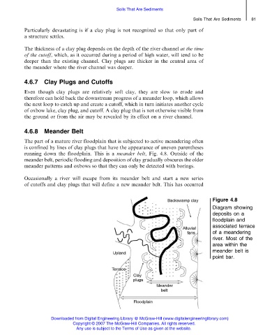
4.6.8 Meander Belt
The part of a mature river floodplain that is subjected to active meandering often
is confined by lines of clay plugs that have the appearance of uneven parentheses
running down the floodplain. This is a meander belt, Fig. 4.8. Outside of the
meander belt, periodic flooding and deposition of clay gradually obscures the older
meander patterns and oxbows so that they can only be detected with borings.
Occasionally a river will escape from its meander belt and start a new series
of cutoffs and clay plugs that will define a new meander belt. This has occurred
Figure 4.8
Diagram showing
deposits on a
floodplain and
associated terrace
of a meandering
river. Most of the
area within the
meander belt is
point bar.
Downloaded from Digital Engineering Library @ McGraw-Hill (www.digitalengineeringlibrary.com)
Copyright © 2007 The McGraw-Hill Companies. All rights reserved.
Any use is subject to the Terms of Use as given at the website.