Page 51 - Geothermal Energy Systems Exploration, Development, and Utilization
P. 51

1.3 Conceptual Models of Geothermal Reservoirs  27

                                                                                    114°00′
                                              Cascade Arc
                                  Juan
                                   de             Basin
                                  Fuca             and                        Boundary of
                                                                              great basin      42°00′
                                                  range
                          Mendocino              Walker
                              F. Z.              Lane
                                MTJ
                            San Andreas
                               Fault                              SIERRA NEVADA
                                                                              Walker lane
                                   Pacific
                                   plate                       SAN ANDREAS FAULT
                          0 Ma                                                           0    100 mi.
                                                                            ECSZ
                                                                                         0  100 km
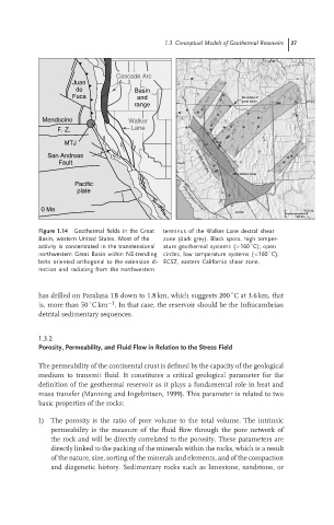
                         Figure 1.14  Geothermal fields in the Great  terminus of the Walker Lane dextral shear
                         Basin, western United States. Most of the  zone (dark grey). Black spots, high temper-
                                                                                ◦
                         activity is concentrated in the transtensional  ature geothermal systems (>160 C); open
                                                                                     ◦
                         northwestern Great Basin within NE-trending circles, low temperature systems (<160 C);
                         belts oriented orthogonal to the extension di- ECSZ, eastern California shear zone.
                         rection and radiating from the northwestern

                                                                           ◦
                         has drilled on Paralana 1B down to 1.8 km, which suggests 200 Cat3.6 km,that
                                           −1
                                       ◦
                         is, more than 50 Ckm . In that case, the reservoir should be the Infracambrian
                         detrital sedimentary sequences.
                         1.3.2
                         Porosity, Permeability, and Fluid Flow in Relation to the Stress Field

                         The permeability of the continental crust is defined by the capacity of the geological
                         medium to transmit fluid. It constitutes a critical geological parameter for the
                         definition of the geothermal reservoir as it plays a fundamental role in heat and
                         mass transfer (Manning and Ingebritsen, 1999). This parameter is related to two
                         basic properties of the rocks:

                         1) The porosity is the ratio of pore volume to the total volume. The intrinsic
                             permeability is the measure of the fluid flow through the pore network of
                             the rock and will be directly correlated to the porosity. These parameters are
                             directly linked to the packing of the minerals within the rocks, which is a result
                             of the nature, size, sorting of the minerals and elements, and of the compaction
                             and diagenetic history. Sedimentary rocks such as limestone, sandstone, or
   46   47   48   49   50   51   52   53   54   55   56