
Page 61 - Handbook of Gold Exploration and Evaluation
P. 61
42 Handbook of gold exploration and evaluation
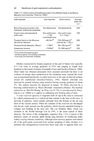
Table 1.11 Gold content and gold grain size in the different types of auriferous
deposits (from Sanchez-Palencia, 1992)
Gold deposits Size deposits Gold content Average
grain size
( )
Bed of heaving minerals in the Not determined Not determined 230
Cambrian-Ordovician quartzites
Quartz veins and associated Not well known Not well known 150
wall-rocks <1 Mt 0.1±10g/t a
(individual vein)
Proximal facies in the Miocene <60Mm 3b 150±300mg/m 3c 300
alluvial fan deposits (detrital Au > 50 )
Pliocene fluvial deposits (`Rana') <7 Mm 3 80±100 mg/m 3c 200
Quaternary terraces <70Mm 3 70±250 mg/m 3c 220
a
From small and isolated samples.
b
Auriferous gravel, not including overburden.
c
From large and systematic sampling.
Ditches constructed by Roman engineers in this part of Spain were typically
0.3±1.5 m wide, at average gradients of 0.5% and ranging in length from
hundreds to thousands of metres (Fernandez-Posse and Sanchez-Palencia, 1988).
Ditch water was obtained principally from seasonal snowmelt but there is no
evidence of storage dam construction in the catchment areas. Instead, the water
was accumulated periodically in small reservoirs at the tops of alluvial sections
chosen for exploitation (Sanchez-Palencia, 1992). Shallow alluvium was
removed by ground sluicing using trenches having average gradients of about
5%. The authors describe the dispersal of deeper, 30±100 m alluvium by a
booming method known as `Ruina Montium' (mountain collapse). The method,
referred to as `Bell-Pit Mining' by Pliny (AD 23±79), is reconstructed by Perez-
Garcia et al. (2000) as it applies to collapsing and flushing piles of talus.
A water reservoir (piscina or stagnum) built on top of the talus is connected
by a ditch (emissarium) to a vertical pit that extends to the base of the talus. A
network of galleries, which radiate outwards from the bottom of the pit stop
short of the outside surface. When the contents of the reservoir are discharged
into the pit, water spreads into the galleries, which become saturated leading to
collapse and flushing of the talus pile. The Las Medulas Mine, which was
included in the World Heritage List in 1997, is the most typical of these
deposits. The nature of the stratigraphic sequence (Fig. 1.15) is typical of the
pulsatory nature of tectonic uplift during long histories of weathering under
widely varying climatic conditions. Although some mercury appears with almost
all of the gold grains recovered from current sampling of mine residues, it is
probable that amalgamation would have been used only to upgrade final con-