
Page 174 - Intelligent Digital Oil And Gas Fields
P. 174
Components of Artificial Intelligence and Data Analytics 133
Stundner (2007) and Dossary et al. (2016) use SOMs to explore and identify
regions in reservoir simulation models, based on geological signatures and/
or (dis)similarities. Such SOM models condition geology to reservoir flow
dynamics and reduce simulation model computational requirements for
inversion and assisted history matching (AHM) with minimal engineering
effort. They propose an algorithm that stems from the original Kohonen
algorithm but is redesigned to fit reservoir simulation data. As such, the algo-
rithm is optimized for 3D spatial maps, rather than 2D data considered by the
original Kohonen. The data “discovers” the underlying map rather than
adapting to it, and the similarity metric is not the minimum distance Euclid-
ean norm, but the model transmissibility.
The algorithm optimizes on the desired number of regions in the
simulation model and reduces the complexity of the property matrix size
in the AHM process by several orders of magnitude, which is crucial when
using CPU time and resource-intensive model-inversion techniques.
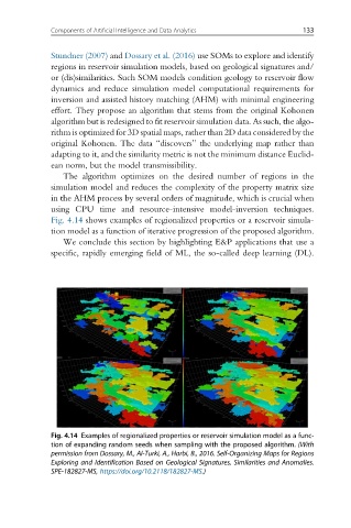
Fig. 4.14 shows examples of regionalized properties or a reservoir simula-
tion model as a function of iterative progression of the proposed algorithm.
We conclude this section by highlighting E&P applications that use a
specific, rapidly emerging field of ML, the so-called deep learning (DL).
Fig. 4.14 Examples of regionalized properties or reservoir simulation model as a func-
tion of expanding random seeds when sampling with the proposed algorithm. (With
permission from Dossary, M., Al-Turki, A., Harbi, B., 2016. Self-Organizing Maps for Regions
Exploring and Identification Based on Geological Signatures, Similarities and Anomalies.
SPE-182827-MS, https://doi.org/10.2118/182827-MS.)