
Page 396 - Intelligent Digital Oil And Gas Fields
P. 396
334 Intelligent Digital Oil and Gas Fields
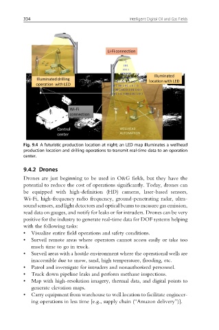
Fig. 9.4 A futuristic production location at night; an LED map illuminates a wellhead
production location and drilling operations to transmit real-time data to an operation
center.
9.4.2 Drones
Drones are just beginning to be used in O&G fields, but they have the
potential to reduce the cost of operations significantly. Today, drones can
be equipped with high-definition (HD) cameras, laser-based sensors,
Wi-Fi, high-frequency radio frequency, ground-penetrating radar, ultra-
sound sensors, and light detectors and optical beams to measure gas emission,
read data on gauges, and notify for leaks or for intruders. Drones can be very
positive for the industry to generate real-time data for DOF systems helping
with the following tasks:
• Visualize entire field operations and safety conditions.
• Surveil remote areas where operators cannot access easily or take too
much time to go in truck.
• Surveil areas with a hostile environment where the operational wells are
inaccessible due to snow, sand, high temperature, flooding, etc.
• Patrol and investigate for intruders and nonauthorized personnel.
• Track down pipeline leaks and perform methane inspections.
• Map with high-resolution imagery, thermal data, and digital points to
generate elevation maps.
• Carry equipment from warehouse to well location to facilitate engineer-
ing operations in less time [e.g., supply chain (“Amazon delivery”)].