
Page 54 - Intro to Space Sciences Spacecraft Applications
P. 54
Orbital Principles
41
only the side-to-side distance over the surface of the earth scanned by the
sensor, which may be much less than the geometric swath width described
here. The same is true of the footprint area viewed by a particular sensor.
When discussing the angles through which a sensor may scan, the sensor
field of view may be different from the angular field of view described
here, and the angles viewed may also be identified as the nadir angle or
the look angle. Usually, the context in which these terms are used will
clarify the intended meaning.
Ground Track
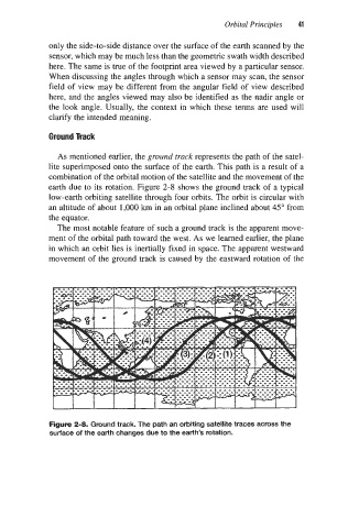
As mentioned earlier, the ground truck represents the path of the satel-
lite superimposed onto the surface of the earth. This path is a result of a
combination of the orbital motion of the satellite and the movement of the
earth due to its rotation. Figure 2-8 shows the ground track of a typical
low-earth orbiting satellite through four orbits. The orbit is circular with
an altitude of about 1,000 km in an orbital plane inclined about 45" from
the equator.
The most notable feature of such a ground track is the apparent move-
ment of the orbital path toward the west. As we learned earlier, the plane
in which an orbit lies is inertially fixed in space. The apparent westward
movement of the ground track is caused by the eastward rotation of the
Figure 2-8. Ground track. The path an orbiting satellite traces across the
surface of the earth changes due to the earth's rotation.