
Page 271 - Numerical Analysis and Modelling in Geomechanics
P. 271
252 SEISMIC MICROZONING USING NUMERICAL MODELLING
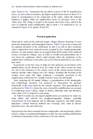
sides. Figure 8.16c summarizes the site effects in terms of the Fa amplification
factor. As well as the acceleration, the highest amplification factor of about 2.5 is
found in correspondence of the central part of the valley, where the sediment
thickness is higher, while the amplification factor Fa decreases close to the
valley sides. The village is located on the eastern side of the valley, which is the
zone of relatively small amplification, that is about 1.5 if expressed as Fa, as
reported in Figure 8.16c (points 26 and 29).
Practical application
Observations made on the analysed sample villages allowed clustering of some
particular stratigraphic and topographic features. Table 8.5 gives the average and
the standard deviation of the coefficients Fa and A as well as their maximum
values computed in each analysed section, grouped by four morphostratigraphic
features. Fa and A mean values are averaged along all the nodes of the analysed
section, crossing the villages’ area, in order to smooth some particularity due to
very local site conditions, which could strongly affect the attribution of the
amplification coefficient to the entire area as the columns labelled Fa-max and A-
max show.
In particular, in the few cases of slope toe sites analysed, an increment of the
amplifications can be observed from the centre of the valley toward the slope
toe, due to the refraction of the seismic waves at the contact (ramp) between
bedrock and the valley fillings (see Cesi village). Similarly the focusing of the
seismic waves near cliff edges produced a systematic increment in the
amplification coefficients for a length of about 3 times the cliff height.
After analysing the 60 sample villages, a generalization of the stratigraphic
and morphologic situations was produced, to characterize the geologic
framework of the area struck by the seismic sequence. This generalization is
synthesized in Table 8.6, where the zones of possible amplifications are grouped
by morphology types (valleys, ridges or slopes), lithologic units and thickness,
and a value of Fa is assigned to each group.
As Table 8.6 points out, the largest amplifications are produced by slope toe,
slope debris and alluvial fan morphostratigraphic features, generally
characterized by loose deposits and by lithologic sequences with high seismic
impedance contrast between bedrock and overlying soils, such as fluvial-
lacustrine clays, silts and colluvium.
Superposition has been assumed between stratigraphic and morphologic effects,
such as a ridge in uncemented formations; in this case the resulting amplification
coefficient is the product of the coefficients of the two effects.