
Page 107 - Petroleum Geology
P. 107
86
by the needs of the exploration industry, have made seismic surveys the
most important geophysical tool in petroleum geology.
Just as we can get an echo from across a steep valley when we shout or
fire a gun, so can we get an echo from rock surfaces beneath us when we
cause an elastic wave or pulse to pass down through the rocks. Just as we can
estimate the distance to the cliff echoing our voice by measuring the time
taken for sound to cross the valley and return at a speed of about 330 m/s,
so can we estimate the depth to a subsurface reflector by measuring the two-
way time, and estimating or measuring the velocity of the energy wave
through the porous rocks (typically 2-4 km/s). A seismic reflection survey
consists of generating energy waves from shot points and recording the re-
flections by means of geophones in known positions. At each point, a re-
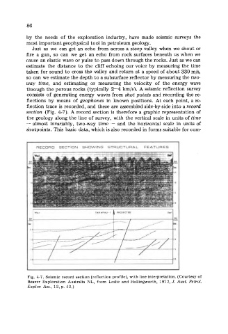
flection trace is recorded, and these are assembled side-by-side into a record
section (Fig. 4-7). A record section is therefore a graphic representation of
the geology along the line of survey, with the vertical scale in units of time
- almost invariably, two-way time - and the horizontal scale in units of
shotpoints. This basic data, which is also recorded in forms suitable for com-
RECORD SECTION SHOWING STRUCTURAL FEATURES
TAKAPAU-l 1 PROJECTED
20 / I
I
Fig. 4-7. Seismic record section (reflection profile), with line interpretation. (Courtesy of
Beaver Exploration Australia NL, from Leslie and Hollingworth, 1972, J. Aust. Petrol.
Explor. Ass., 12, p. 42.)