
Page 300 - Petroleum Geology
P. 300
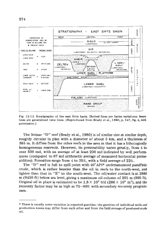
274


                                  STRATIGRAPHY  -  EAST  SIRTE  BASIN

                                  WEST            CENTRAL
                  COMPARISON  Of
               NOMENCLlTURE  USE0  BY
                TERRY  a  WILLIAMS  1969                   ELGlZI  MEMBER
                                                 (LIMESTONES)                Y
                 8  PRESENT  PAPER
                                                                             Y
                                                   GIR
             TERRY  8  WILLIAMS   PRESENT  PAPER
                                          (LIMESTONES - DOLOMhTES - INHIDrllTESJ
              UPPER  KHEIR
                        XHEIR
              LOWER  KHLIR
              ZELTEN    UPPER  SABlL
              IDRlS     INTISAR
              LOWER  ZELTEN   UPPER  SABlL
              CARBONATE   PLATFORM
              HElRA  SHALE   SHETERAT
                                               (LIMESTONES  /  DOLOMITES  )
              HEIRA  LI I   LOWER  SABlL
              DOLOMiTE


                                                                .   .  .
            Fig. 12-12. Stratigraphy of the east  Sirte  basin.  Dotted  lines are facies variations:  heavy
            lines are generalized  time lines. (Reproduced  from Brady et al., 1980, p. 547, fig. 4, with
            permission. )

              The Intisar “D”  reef  (Brady et al., 1980) is of similar size at similar depth,
            roughly  circular in plan with  a diameter of about 5 km, and a thickness of
            385 m. It differs from the other reefs in the area in that it has a lithologically
            homogeneous reservoir.  However, its permeability varies greatly, from 4 to
            over 500 md, with an average of  at least 200 md indicated by well perform-
            ances (compared to 87 md arithmetic average of measured horizontal perme-
            ablities). Porosities range from 4 to 35%, with a field average of 22%.
              The “D”  reef  is full to spill point with 40”API” undersaturated paraffinic
            crude,  which  is rather  heavier  than  the  oil in  reefs to the north-west, and
            lighter than that in “E”  to the south-west. The oil/water contact is at 2880
            m (9450 ft) below sea level, giving a maximum oil column of 291 m (995 ft).
            Original oil in place is estimated to be 1.8 X  lo9 bbl (286 X  lo6 m3), and the
            recovery factor may be as high as 75-80%  with secondary recovery program-
            mes.


            * There is usually some variation in reported gravities: the gravities of individual wells and
            production zones may differ from each other and from the field average of produced crude
            oil.