
Page 307 - Petroleum Geology
P. 307
281
0 10 50 km E
0 15 30 miles I AUGlLA I
I FIELD I LOWER fe e t
&-=I EOCENE
W I 5pOO
LOWER
EOCENE
. 10,ooc
UPPER
CRETACEOUS
- I5,OOC
EAST-WEST SECTION
EASTERN SIRTE BASIN
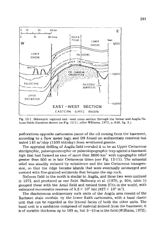
Fig. 13-1. Schematic regional east-west cross section through the Intisar and Augila-Na-
foora fields (location shown on Fig. 12-11; after WiIliams, 1972, p. 626, fig. 3.)
perforations opposite carbonates (most of the oil coming from the basement,
according to a flow meter log); and D9 found no sedimentary reservoir but
tested 140 m3/day (1500 bbl/day) from weathered granite.
The appraisal drilling of Augila field revealed it to be an Upper Cretaceous
stratigraphic, palaeogeomorphic or palaeotopographic trap against a basement
high that had formed an area of more than 2600 km2 with topographic relief
greater than 600 m in late Cretaceous times (see Fig. 12-11). The subaerial
relief was steadily reduced by subsidence and the late Cretaceous transgres-
sion, so that the ridge became islands that were eventually submerged and
covered with fine-grained sediments that became the cap rock.
Nafoora field to the north is similar to Augila, and these two were unitized
in 1971 and produced as one field. Halbouty et al. (1970, p. 504, table 1)
grouped these with the Amal field and ranked them 27th in the world, with
estimated recoverable reserves of 5.2 X lo9 bbl (827 X lo6 m3).
The diachronous sedimentary rock units of the Augila area consist of the
Rachmet shale overlain by the lower Rakb carbonates, with a basal clastic
unit that can be regarded as the littoral facies of both the other units. The
basal unit is a sandstone composed of material derived from the basement; it
is of variable thickness up to 185 m, but 3-10 m in the field (Williams, 1972).