
Page 125 - Standard Handbook Petroleum Natural Gas Engineering VOLUME2
P. 125
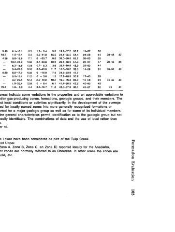
Vlola   0   4.300-  7,300   5,400  3 -73   39.1   3.6-  23  10.6   3.40   3.40   8.1-10.1   9.3   1.7-  9.4   5.0  19.7-37.2  30.7   19-37   30
 0   2.1 00-11,100   4,900   2  -111.7   17.2   0.1-1,150   52.3   0.2-186   18.3   1.0-16.1   8.4   3.2-41  .O   15.5  24.1-85.5  54.4   24-86   51   28-48   37
 T   2,600-10.300   4,600   2  -117   19.6   0.1-  997  45.1   0.3-49   4.38   0.6-18.8   7.1   0  -33.7   8.6   39.0-90.8   65.7   39-90   58
 Wayside   0   300-  2,800   800  3.1-34   10.8   0.2-   133  22.2   -  13.2-24.9   18.6   8.1-33.8   18.6  29.4-68.0   51.3   28-67   47   29-42   35
 First Wilcox   0   2,800-  5,400   4,300   2  -35   11.3  0.7-   145  72.1   -   5.2-15.6   10.8   0.7-  8.3   3.6   29.7-80.5   43.9   29-60   44
 0   2,800-  7.400   4,900   2  -26   10.0   0.2-  445  913   -   -   5.4-20.5   12.0   3.8-40.5   11.7   15.0-58.2   32.0   14-56   31   33-50   42
 T   3.200-  6,100   3,900   1.9-29   7.7   0.2-  418  84.1   0.80   0.80   6.8-17.7   10.9   0  -16.9   7.9   24.0-63.6  41.7
 Second   0   5,000-1  0,000   6,700   5  -28   13.4   0.2-   154  76.2   -   -   5.0-15.1   11.2   0  - 3.8   1.5   17.7-45.8  30.9   17-43   29
 Wilcox   0   3,700-  8,400   6,500   1.3-32   11.3   0.4-2.960   214   -   4.2-20.6   12.4   2.9-19.2   10.2   19.0-56.3  36.9   18-56   34   34-42   40
 T   4,700-  7,500   6,000   1.5-  5   4.4   0.4-  756  246   -   -   1.9-20.4   12.9   0  - 8.4   8.1   41.4-60.5   42.5   40-80   43
 Woodford   0   4,100-  5,000   4,800   2.6-30.4   16.2   1.4-  250  87.1   2.4-156   79.2   1.9-  6.6   4.4   8.3-16.7   11.8  43.0-87.9  60.1   43-87   60   41   41
 a  General geologic  sections taken  at different points in Oklahoma-Kansas  areas indicate some variations in the properties and an appreciable variatlons in
 the occurrence and relative depths of  many of  the more important oil- and/or gas-producing zones, formations,  geologic groups, and their members. The
 general identification of  core samples from these producing intervals reflect local conditions or activities significantly.  In the development of  the average
 data values,  an attempt has been made to combine data originally reported for locally named zones into more generally  recognized formations or
 geologic  groups.  In some instances (Le.,  Deese, Cherokee) data are reported for a major geologic group as well as for some of  its individual members.
 The values designated by the major group name represent areas where the general characteristics permit identification as to the geologic group but not
 as to group members.  In other areas the group members or zones are readily identifiable. The combinations of  data and the  use of  local rather than
 regional geologic names in some instances are explained in the footnotes.
 b T Represents transition zone or production of  both water and either gas or oil.
 Includes data reported as  Domick Hills and Dutcher.
 Includes Bromide First and Second as  reported on  McClain County area.
 e  Data reported locally as Bromide Third,  Bromide Upper third,  and Bromide Lower have been considered as part of  the Tulip Creek.
 Includes data reported as  Cleveland Sand,  Cleveland, Lower, and Cleveland Upper.
 Includes the  numerous zones (Deese First, Second, Third,  Fourth, Fifth, Zone A.  Zone  E,  Zone  C,  an Zone  D)  reported locally for the Anadarko,
 Ardmore,  and Marietta Basin areas. In northwest Oklahoma, these different zones are normally referred to as Cherokee. In other areas the zones  are
 frequently identlflable and properties are reported as for Redfork, Bartlesville, etc.


                                                 c
                                                 0
                                                 w