
Page 65 - The Petroleum System From Source to Trap
P. 65
58 Klemme
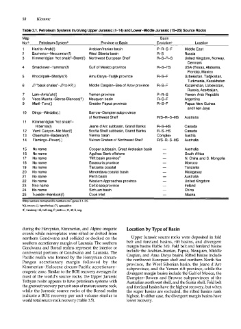
Table 3.1 . Petroleum Systems Involving Upper Jurassic (1-14) and Lower-Middle Jurassic (15-25) Source Rocks
Map Basin
No.a Petroleum S�stemb Province or Basin Evolutionc Location
Hanifa-Arab(!) Arabian/Iranian basin P-R-S-F Middle East
2 Bazhenov-Neocomian(!) West Siberia basin R-S Russia
3 Kimmeridgian "hot shale"-Brent(!) Northwest European Shelf R-S-R-S United Kingdom, Norway,
Denmark
4 Smackover-Tamman(!) Gulf of Mexico province R-S-HS USA (Texas, Alabama,
Florida), Mexico
5 Khodzipaik-Shatlyk(?) Amu Darya-Tadjik province R-S-F Uzbekistan, Tadjikistan,
Turkmenia, Kazakhstan
6 J3 "black shales"-J3 to K2(.) Middle Caspian-Sea of Azov province R-S-F Kazakhstan, Uzbekistan,
Russia, Azerbaijan,
7 Lam-Amla'ah(!) Yemen province P-R-S Yemen Arab Republic
8 Vaca Muerta-Sierras Blancas(?) Neuquen basin R-S-F Argentina
9 Maril-Toro(.) Greater Papua province R-S-F Papua New Guinea
and Irian Jay a
10 Dingo-Windalia(.) Barrow-Dampier subprovince
of Northwest Shelf R/S-R-S-HS Australia
11 Kimmeridgian "hot shale"-
Hibernia(!) Jeane d'Arc subbasin, Grand Banks R-S-HS Canada
12 Verril Canyon-Mic Mac(!) Scotia Shelf subbasin, Grand Banks R-S-HS Canada
13 Obermalm-Badenian(!) Vienna basin Complex Austria
14 Flamingo-Plover(.) Vulcan Graben of Northwest Shelf R/S-R-S-HS Australia
15 No name Cooper subbasin, Great Aretesian basin Australia
16 No name Agulhas Bank offshore South Africa
17 No name "Rift basin province" N. China and S. Mongolia
18 No name Essaouria province Morro co
19 No name Tanzania coastal Tanzania
20 No name Morondava coastal basin Malagasay
21 No name Perth basin Australia
22 No name Western Approaches province United Kingdom
23 Nno name Celtic sea province Ireland
24 No name Sichuan basin China
25 Tuxedni-Hemlock(!) Cook Inlet Alaska
•Map numbers correspond to numbers on Figures 3.1-3.5.
b (!), krown; (.), hypothetical; (?), speculative.
cF, foredeep; HS, half-5ag; P, platform; R, rift; S, sag.
during the Hercynian, Kimmerian, and Alpine orogenic Location by T y pe of Basin
events while microplates were rifted or drifted from
northern Gondwana and collided or docked on the Upper Jurassic source rocks were deposited in fold
southern accretionary margin of Laurasia. The southern belt and foreland basins, rift basins, and divergent
Gondwana and Boreal realms represent the interior or margin basins (Table 3.6). Fold belt and foreland basins
continental portions of Gondwana and Laurasia. The include the Arabian-Iranian, Papua, Neuquen, Middle
Pacific realm was formed by the Hercynian circum Caspian, and Arnu Darya basins. Rifted basins include
Pangea accretionary margin followed by the the northwest European shelf and northern North Sea
province, the West Siberian basin, the Jeane d'Arc
Kimmerian-Holocene circum-Pacific accretionary subprovince, and the Yemen rift province, -while the
orogenic zone. Similar to the BOE recovery averages for divergent margin basins include the Gulf of Mexico, the
most of the world's source rocks, the Upper Jurassic Dampier-Bowen and Browse subprovinces of the
Tethyan realm appears to have petroleum systems with Australian northwest shelf, and the Scotia shelf. Fold belt
the greatest recovery per unit area of mature source rock, and foreland basins have the highest recovery, but when
while the Jurassic source rocks of the Boreal realm the super basins are excluded, the rifted basins rank
indicate a BOE recovery per unit volume similar to highest. In either case, the divergent margin basins have
world total source rock recovery (Table 3.5). lower recovery.