
Page 156 - Volcano and Geothermal Tourism
P. 156
The Need for a Planning Framework to Preserve the Wilderness Values of Sibayak Volcano, North Sumatra, Indonesia 133
lack of signage and the presence of a loose
boulder-strewn surface at the upper levels have
resulted in trail bifurcation and widening, and
pose risks to the unwary visitor.
Activities at the summit include sightseeing,
filming fumerole activity, photography, some
camping and exploring the crater area. Often
these activities are conducted in a random fashion
along user created trails and access points which
has led to informal trail proliferation and dispersed
erosion scaring of the landscape. There is a lack of
on-site management, such as signage that relates to
keeping people on walk trails and out of the crater
area. Some graffiti and littering is also present
in the summit area. The crater floor has been
modified in the form of lines of stones that have
been arranged into names and words (Figure 8.3).
The geometric arrangement of stones constitutes
a visual impact that is likely to impoverish natural
values of the most significant part of the viewing
experience for some visitors.
There is no interpretation in place to enrich
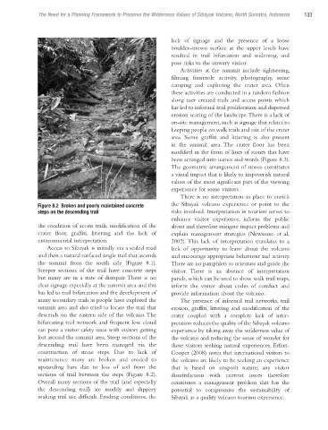
Figure 8.2 Broken and poorly maintained concrete the Sibayak volcano experience or point to the
steps on the descending trail risks involved. Interpretation in tourism serves to
enhance visitor experience, inform the public
the condition of access trails, modification of the about and therefore mitigate impact problems and
crater floor, graffiti, littering and the lack of explain management strategies (Newsome et al,
environmental interpretation. 2002). This lack of interpretation translates to a
Access to Sibayak is initially via a sealed road lack of opportunity to learn about the volcano
and then a natural surfaced single trail that ascends and encourage appropriate behaviour and activity.
the summit from the south side (Figure 8.1). There are no pamphlets to orientate and guide the
Steeper sections of the trail have concrete steps visitor. There is an absence of interpretation
but many are in a state of disrepair. There is no panels, which can be used to show walk trail maps,
clear signage especially at the summit area and this inform the visitor about codes of conduct and
has led to trail bifurcation and the development of provide information about the volcano.
many secondary trails as people have explored the The presence of informal trail networks, trail
summit area and also tried to locate the trail that erosion, graffiti, littering and modification of the
descends on the eastern side of the volcano. The crater coupled with a complete lack of inter-
bifurcating trail network and frequent low cloud pretation reduces the quality of the Sibayak volcano
can pose a visitor safety issue with visitors getting experience by taking away the wilderness value of
lost around the summit area. Steep sections of the the volcano and reducing the sense of wonder for
descending trail have been managed via the those visitors seeking natural experiences. Erfurt-
construction of stone steps. Due to lack of Cooper (2008) notes that international visitors to
maintenance many are broken and eroded to the volcano are likely to be seeking an experience
upstanding bars due to loss of soil from the that is based on unspoilt nature; any visitor
sections of trail between the steps (Figure 8.2). dissatisfaction with current issues therefore
Overall many sections of the trail (and especially constitutes a management problem that has the
the descending trail) are muddy and slippery potential to compromise the sustaina bility of
making trail use difficult. Eroding conditions, the Sibayak as a quality volcano tourism experience.
Ch08.indd 133 3/28/2010 1:28:17 PM