
Page 204 - Volcano and Geothermal Tourism
P. 204
Volcano Tourism in Iran: Mt Damavand, the Highest Peak in the Middle East 181
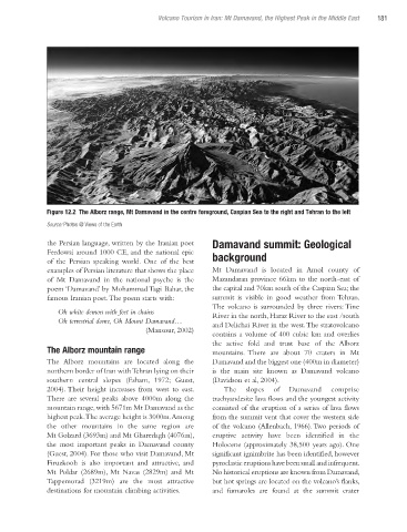
Figure 12.2 The Alborz range, Mt Damavand in the centre foreground, Caspian Sea to the right and Tehran to the left
Source: Photos @ Views of the Earth
the Persian language, written by the Iranian poet Damavand summit: Geological
Ferdowsi around 1000 CE, and the national epic background
of the Persian speaking world. One of the best
examples of Persian literature that shows the place Mt Damavand is located in Amol county of
of Mt Damavand in the national psyche is the Mazandaran province 66km to the north-east of
poem ‘Damavand’ by Mohammad Tagi Bahar, the the capital and 70km south of the Caspian Sea; the
famous Iranian poet. The poem starts with: summit is visible in good weather from Tehran.
The volcano is surrounded by three rivers: Tine
Oh white demon with feet in chains River in the north, Haraz River to the east /south
Oh terrestrial dome, Oh Mount Damavand… and Delichai River in the west. The stratovolcano
(Mansour, 2002)
contains a volume of 400 cubic km and overlies
the active fold and trust base of the Alborz
The Alborz mountain range mountains. There are about 70 craters in Mt
The Alborz mountains are located along the Damavand and the biggest one (400m in diameter)
northern border of Iran with Tehran lying on their is the main site known as Damavand volcano
southern central slopes (Esham, 1972; Guest, (Davidson et al, 2004).
2004). Their height increases from west to east. The slopes of Damavand comprise
There are several peaks above 4000m along the trachyandesite lava flows and the youngest activity
mountain range, with 5671m Mt Damavand as the consisted of the eruption of a series of lava flows
highest peak. The average height is 3000m. Among from the summit vent that cover the western side
the other mountains in the same region are of the volcano (Allenbach, 1966). Two periods of
Mt Golzard (3693m) and Mt Gharedagh (4076m), eruptive activity have been identified in the
the most important peaks in Damavand county Holocene (approximately 38,500 years ago). One
(Guest, 2004). For those who visit Damavand, Mt significant ignimbrite has been identified, however
Firuzkooh is also important and attractive, and pyroclastic eruptions have been small and infrequent.
Mt Poldar (2689m), Mt Navas (2829m) and Mt No historical eruptions are known from Damavand,
Tappemorad (3219m) are the most attractive but hot springs are located on the volcano’s flanks,
destinations for mountain climbing activities. and fumaroles are found at the summit crater
Ch12.indd 181 3/28/2010 1:29:41 PM