Page 42 - An Atlas of Carboniferous Basin Evolution in Northern England
P. 42

Carboniferous  basin  development                                                                                        23

                                                                                                                                                          Evans & Kirby  1999). These  facies and  thickness variations  indicate  a  southern
                                                                                                                                                          fault-bounded  basin  margin  situated  at  depth  below  the  inversion-related
                                                                                                                                                          Pendle Monocline  (Fig.  18), with carbonate  platform  margins developed  in the
                                                                                                                                                          Chadian,  Arundian  and  Asbian/Brigantian  (Evans  &  Kirby  1999).  The
                                                                                                                                                          northern  margin  of  the  basin  is  marked  by  facies  and  thickness  changes  on
                                                                                                                                                          to the Bowland High (Gawthorpe  1987a; Lawrence et al  1987; Arthurton  et al.
                                                                                                                                                           1988)  and  the  Askrigg Block  (Tiddeman  1889; Hudson  1930).
                                                                                                                                                            Within  the basin, basement  has not been penetrated  by any borehole  to  date,
                                                                                                                                                          the  oldest  proven  sediments  being  of  Courceyan  age  (EClb).  These  were
                                                                                                                                                          penetrated  by the  Swinden  borehole  and  comprise  sub-wavebase,  argillaceous
                                                                                                                                                          packstones  deposited  on the distal portion of a carbonate ramp  (Gawthorpe et
                                                                                                                                                          al.  1989). This general  style of sedimentation  continued  into  the Chadian  (EC2;
                                                                                                                                                          Chatburn  and  Thornton  Limestones). Thickness  and  facies  variations  indicate
                                                                                                                                                          some  degree  of  structural  control  which  was  inherited  from  earlier  late
                                                                                                                                                          Devonian-Courceyan  (ECl)  rifting.  Waulsortian carbonate  buildups are often
                                                                                                                                                          associated with the flanks of intra-basinal fault  blocks (Miller & Grayson  1982;
                                                                                                                                                          Lees  &  Miller  1985)  that  formed  the  sites  of  major  Variscan  inversion
                                                                                                                                                          structures  (e.g.  Clitheroe,  Hetton-Eshton  and  Slaidburn  anticlines;  Arthurton
                                                                                                                                                          1984;  Gawthorpe  1987a; Arthurton  et  al  1988).
                                                                                                                                                            The late Chadian-Holkerian (EC3)  was marked  by the rapid  development  of
                                                                                                                                                          sea-floor  topography,  indicated  by  thickness  and  facies  differentiation  across
                                                                                                                                                          the  basin  (Gawthorpe  1987a).  This  topography  was  associated  with  reactiva-
                                                                                                                                                          tion of extensional faults  and  the development of local footwall unconformities
                                                                                                                                                          within the basin. The  succession in the basin  became  dominated  by  mudstones
                                                                                                                                                          (Worston  Shales)  with  local  developments  of  siliciclastic  turbidites  and
                                                                                                                                                          sedimentary  slides  (Gawthorpe  &  Clemmey  1985).  In  addition  Pb-Zn
                                                                                                                                                          mineralization  is  associated  with  these  events  (Gawthorpe  et  al.  1989).  The
                                                                                                                                                          succeeding  Holkerian  to  early  Asbian  (EC4)  shows  a  progressive  increase  in
                                                                                                                                                          carbonate  sedimentation,  culminating  in  the  development  of  carbonate-
                                                                                                                                                          rimmed  shelves  along  the  northern  margin  of the  basin.
                                                                                                                                                            A  further  phase  of  tectonism  occurred  during  the  late  Asbian  to  early
                                                                                                                                                          Brigantian  (EC5)  (Gawthorpe  1986).  This  phase,  which  comprised  several
                                                                                                                                                          events,  is  characterized  by  major  units  of  resedimented  carbonate  conglom-
                                                                                                                                                          erate, the common  occurrence of soft  sediment deformation  features and  major
                                                                                                                                                          facies  and  thickness variations within the  basin  and  across  the northern  basin
                                                                                                                                                          margin.  Background  sedimentation  became  dominated  by  deep  marine
                                                                                                                                                          mudstone  (Bowland  Shales)  with  influxes  of  coarse  grained  siliciclastic
                                                                                                                                                          turbidites  (mid-Brigantian  Pendleside  Sandstone).  Facies  distributions  and
                                                                                                                                                          thickness  variations  indicate  southerly  downthrow  on  the  Middle  Craven
                                                                                                                                                          Fault.  However,  slip  reversal  along  this  fault  in  the  Brigantian  may  be
                                                                                                                                                          indicated  by  uplift  and  erosion  of  carbonate  buildups  in  the  hanging-wall
                                                                                                                                                          (Mundy  1980).
                                                                                                                                                            Namurian  and  Westphalian strata  are  some  2 km  thick  in the  syncline that
                                                                                                                                                          separates  the  Pendle  Monocline  from  the  Rossendale  High  (Lancashire
                                                                                                                                                          Coalfield),  and  about  1500 m  in the  Holme Chapel  and  Boulsworth  boreholes
                                                                                                                                                          (Fig.  18). There  is no  direct  evidence  for  original  thicknesses  over  the  central
                                                                                                                                                          part  of  the  basin,  but  they  are  likely  to  have  been  in  excess  of  the  preserved
                                                                                                                                                          2km.  Pendleian  facies  are  typical  Millstone  Grits  and  Coal  Measures,
                                                                                                                                                          pervasive  over  this  part  of  the  central  Pennine  Basin.  However,  the  initial
                                                                                                                                                          clastic  infill  of delta-front  turbidites (the  Pendleian  aged  Pendle  Grit; LC1 a) is
                                                                                                                                                          much  older  than  in the  East  Midlands (e.g. Widmerpool  Gulf).


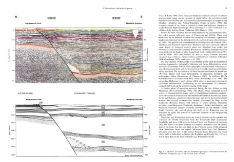
                                                                                                                                                          Fig.  21. Composite  2D  seismic line  and  interpreted geological cross-section  across  the
                                                                                                                                                          Stainmore  Trough  (see  Fig.  10 for  location  of  the  seismic).
   37   38   39   40   41   42   43   44   45   46   47