
Page 68 - An Atlas of Carboniferous Basin Evolution in Northern England
P. 68
and
Palaeogeography
abundant
increasingly
By Westphalian A times, the Namurian deltas had established a low lying marine bivalves and fish beds become fades evolution with time 47
coastal plain over northern England (e.g. Guion & Fielding 1988). Sedimentary reflecting the establishment of upper delta-plain environments. The area was
environments were dominated by swamps and brackish and fresh water dominated by coal swamps and meandering fluvial channels. Sedimentation
lagoons where mudstones, siltstones and coals accumulated, and distributary was less controlled by the underlying structure, and the ancient basins such as
and crevasse channels formed the main sandbodies. The 'Coal Measures' show the Widmerpool Gulf and Gainsborough Trough ceased to influence the
a cyclicity with black and dark grey mudstones coarsening upwards into location of major distributary channels. Abrupt changes in sandstone
siltstones and sandstones generally with the development of a seatearth and petrography occur in the Yorkshire Coalfield associated with the Westphalian
coal at the top. The thin marine bands are important for correlation B Woolley Edge Rock and are interpreted to reflect a change from westerly to
particularly in Westphalian A times. As with the late Dinantian and Namurian southerly provenance (e.g. Hallsworth and Chisholm 2000). This major
cyclicity, glacio-eustasy was a dominant control. provenance change is also associated with up to 50 m of incision at the base of
The Crawshaw shallow water delta dominated the East Midlands and the Woolley Edge Rock in the East Midlands (Aitken et al. 1999) and is
Derbyshire during early Westphalian A times (Fig. 40). The Crawshaw interpreted to reflect an intra-LC2 inversion event in northern England (e.g.
channels flowed westwards across the East Midlands either reflecting southeast Gainsborough Trough; Fig. 16). However, the association of local
differential compaction, controlled by underlying structures or constraints inversion and the major change to a southern provenance suggests a clear link
imposed by the Wales-Brabant Massif to the south forcing the rivers to drain to tectonic events in the Variscan organic belt to the south. The southerly-
into the remaining depocentre in the Irish Sea to the west (Guion & Fielding derived sediment dominates the rest of the Westphalian (e.g. Hallsworth &
1988). Chisholm 2000; Hallsworth et al. 2000).
The thickest depocentre for the entire Westphalian A is around the Goyt As the Westphalian progressed conditions became increasingly non-marine,
Trough to Rossendale High (central Pennine Basin). This appears to be the evolving into an internally drained basin. Red beds became more prominent in
focus of all channel systems draining across northern England at this time. later Westphalian times, partly due to the orographic effects of the developing
South of the Craven Fault system the facies is dominated by shallow-water, Variscan mountain belt to the south and to the northward drift of the British
lower delta plain environments (Fig. 40). Northwards this grades into the Isles (Besly 1988; Glover & Powell 1996).
upper delta plain. In the East Midlands, the Foston and Bassingham highs
persisted, but these became swamped by later Westphalian sediments (Fig. 40).
Inversion megasequence
Sequence LC2: post-rift (late Westphalian A-Westpha-
lian C) The inversion megasequence marks a major change in basin configuration,
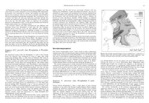
sediment source areas and depositional systems associated with extensive uplift Fig. 41. Map showing estimated Variscan erosion compiled from a combination of
reflectance,
The depositional setting of the late Westphalian A, north of the Variscan of the former rift depocentres during Westphalian C to early Permian times. regional seismic data and burial/uplift estimates from vitrinite 1990). sonic
& Gawthorpe
Fraser
apatite fission-track data
(from
velocities
and
Front, has generally been interpreted in terms of upper delta plain The onset of Carboniferous compressional tectonics, on a regional scale, was
environments (Fielding 1984a, b, 1986; Fulton & Williams 1988; Guion & diachronous from south to north. Foreland basin development in the South
Fielding 1988; Read 1988; Kirk 1989). Important depositional elements include Wales Coalfield started in the early Namurian (Gayer & Jones 1989), whereas (e.g. Bowland Basins; Fig. 41). In contrast, the north-south- and NW-SE-
distributary channels and shallow fresh to brackish lakes that were filled by compressional tectonics leading to basin inversion north of the Wales- trending rift basins (e.g. North Staffordshire Basin, Widmerpool Gulf/
lacustrine deltas, crevasse splays and overbank deposits. The westerly source London-Brabant Massif occurred much later during the Westphalian C. Gainsborough Trough) were oriented more obliquely to the direction of
that became increasingly important in early Westphalian A times formed the The inversion megasequence is mainly associated with the accumulation of maximum shortening and, as a consequence, display significant strike slip. In
dominant source area until mid Westphalian B (e.g. Hallsworth & Chisholm continental red bed molasse facies within growth synclines associated with general, the north-south- and NW-SE-trending rift basins were less strongly
2000; Hallsworth et al 2000). Depositional gradients were low and thus inversion of the syn-rift normal faults (Figs. 41 and 42). In addition to sediment inverted and the Silesian post-rift fill has been retained (Fig. 41).
palaeocurrents in many cases represent local depositional conditions rather sourced from uplifting growth anticlines, sediment was derived from the The lack of preserved section associated with the inversion megasequence
than regional palaeoslopes (Cope et al. 1992). However, in certain areas minor evolving Variscan orogen to the south (e.g. Glover & Powell 1996; Hallsworth across much of northern England precludes detailed palaeogeographic
contemporaneous tectonic activity did influence the pattern of sedimentation. & Chisholm 2000; Hallsworth et al. 2000). As a consequence of basin inversion, analysis. However, reconstruction of inverted faults, coupled with uplift
Fielding (19840), Fielding & Johnson (1987), Guion & Fielding (1988) and post-Carboniferous rocks of various ages rest upon Carboniferous rocks across estimates and extrapolation of data from the West Midlands allows an overall
Aitken et al. (1999) suggest that a number of faults, including the Ninety an angular unconformity (see Figs 12 and 20 from the East Midlands and palaeogeography for the inversion megasequence to be determined (Fig. 42).
Fathom, Butterknowle and Morley-Campsall Faults influenced sedimentation. Cleveland Basin). Data from the East and West Midlands suggest two phases of inversion; a mid-
However, much of this fault activity may be due to differential compaction late Westphalian C phase, and a later, more major, Westphalian D-Stephanian
over earlier structures now at depth. phase (e.g. Wills 1956; Besly 1988; Fraser & Gawthorpe 1990; Corfield et al.
The amount of data available for the Westphalian is immense as a result of Sequence V: inversion (late Westphalian C-early
1996).
However,
condensed
the extensive coal mining activity (e.g. Ramsbottom et al. 1978; Wills 1956; Permian) in north Staffordshire and stratigraphy over the crests of inversion anticlines
the
Trough
suggests
Gainsborough
localized
Guion & Fielding 1988). Thicknesses of up to 3 km are estimated for the inversion pulses may have commenced much earlier in the Westphalian.
Lancashire Coalfield. Local lithostratigraphic nomenclature for coals, sand- During mid-late Westphalian C times, a major phase of basin inversion The complex stratigraphy of the inversion megasequence has been
stones and marine bands seriously hinders regional correlation. Distributary commenced to the north of the Mercian (London-Brabant) Massif, radically collectively referred to as the Westphalian C-D molasse (Corfield et al.
channels were of a highly migratory nature and splitting, pinching-out or changing the sedimentary depocentres and facies patterns across northern 1996). Alternative terms commonly applied are the Barren Red Measures
washing-out of coal seams is common. These factors, together with high England. Dinantian and Namurian basinal areas became inverted, creating (Leeder & Hardman 1990) and Barren Red Beds (Besly et al. 1993). However,
frequency cyclicity, render the construction of a single meaningful LC2 highs that supplied sediment to local growth synclines (Fig. 42). The these names are inappropriate as the Westphalian C-D is neither wholly red
palaeogeography virtually impossible. orientation of the syn-rift basin-bounding fault zones with respect to the nor barren (of coal). In central England, the Westphalian C-D molasse is
After the early Westphalian fluvial-dominated delta systems, typical Coal NW to NNW direction of maximum shortening determined the severity of composed of three distinct lithostratigraphic units; (i) Etruria Formation (late
Measures facies were established across the whole of northern England. The uplift (Corfield et al. 1996). As a consequence, NE-SW-trending rift basins Westphalian C to early Westphalian D), (ii) Newcastle and Halesowen
intermittent marine bands are still of importance for correlation, but non- were strongly inverted, resulting in erosion of much of the Silesian post-rift fill