
Page 72 - An Atlas of Carboniferous Basin Evolution in Northern England
P. 72
Chapter 5
Play fairway analysis
Introduction
Integrated structural and sequence stratigraphic analysis, such as that
described in this Memoir (specifically Chapters 3 and 4), represents a powerful
tool for analysing a petroleum system by identifying hydrocarbon plays and
constraining the regional distribution of the key elements of a play. A play is a
combination of reservoir, source and seal facies which, together with a trap,
may lead to hydrocarbon accumulations at a specific stratigraphic level. The
geographic area over which a play is thought to extend is known as the play
fairway and is usually determined by the depositional and erosional limits of
the reservoir. This need not always be the case, however; play fairways based
on the regional extent of a hydrocarbon source rock system or particular
structural style are equally valid.
Play fairway analysis is essentially an assessment of exploration risk at a
basin scale. In the past the petroleum industry has applied the concept of risk
mainly at a prospect-specific level. On a larger scale, applying risk analysis to
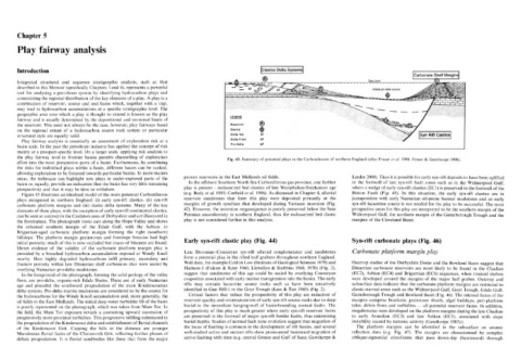
the play fairway level in frontier basins permits channelling of exploration Fig. 43. Summary of potential plays in the Carboniferous of northern England (after Fraser et al. 1990; Fraser & Gawthorpe 1990).
effort into the most prospective parts of a basin. Furthermore, by combining
the risks for individual plays within a basin, different basins can be ranked,
allowing exploration to be focussed towards particular basins. In more mature
areas, the technique can highlight new plays in under-explored parts of the proven reservoirs in the East Midlands oil fields. Leeder 2000). Thus it is possible for early syn-rift deposits to have been uplifted
basin or, equally, provide an indication that the basin has very little remaining In the offshore Southern North Sea Carboniferous gas province, one further in the footwall of late syn-rift fault zones such as in the Widmerpool Gulf,
prospectivity and that it may be time to withdraw. play is present - molasse/red bed elastics of late Westphalian-Stephanian age where a wedge of early syn-rift elastics (EC1) is preserved in the footwall of the
Figure 43 illustrates an idealised model of the main potential Carboniferous (e.g. Besly et al. 1993; Corfield et al. 1996). As discussed in Chapter 4, alluvial Hoton Fault (Fig. 45). In this situation, the early syn-rift elastics are in
plays recognised in northern England: (i) early syn-rift elastics, (ii) syn-rift reservoir sandstones that form this play were deposited primarily at the juxtaposition with early Namurian oil-prone basinal mudstones and an early
carbonate platform margins and (iii) clastic delta systems. Many of the key margins of growth synclines that developed during Variscan inversion (Fig. syn-rift lacustrine source is not needed for the play to be successful. The most
elements of these plays, with the exception of early syn-rift continental elastics, 42). However, the inversion megasequence is poorly preserved below the base prospective areas for this play are interpreted to be the southern margin of the
can be seen at outcrop in the Castleton area of Derbyshire and are illustrated in Permian unconformity in northern England, thus the molasse/red bed clastic Widmerpool Gulf, the northern margin of the Gainsborough Trough and the
the frontispiece. The photograph looks east along the Hope Valley and shows play is not considered further in this analysis. margins of the Cleveland Basin.
the exhumed southern margin of the Edale Gulf, with the Asbian- to
Brigantian-aged carbonate platform margin forming the right (southern)
hillslope. The platform margin grainstones and foreslope breccias had high
initial porosity; much of this is now occluded but traces of bitumen are found. Early syn-rift clastic play (Fig. 44) Syn-rift carbonate plays (Fig. 46)
Direct evidence of the validity of the carbonate platform margin play is
provided by a breached hydrocarbon accumulation exposed at Windy Knoll Late Devonian-Courceyan syn-rift alluvial conglomerates and sandstones Carbonate platform margin play
nearby. Here highly degraded hydrocarbons infill primary, secondary and form a potential play in the rifted half grabens throughout northern England.
fracture porosity within late Dinantian shelf carbonates that were sealed by Well data, for example Caldon Low (Institute of Geological Sciences 1978) and Outcrop studies of the Derbyshire Dome and the Rowland Basin suggest that
overlying Namurian pro-delta mudstones. Hathern-1 (Falcon & Kent 1960, Llewellyn & Stabbins 1968, 1970) (Fig. 2), Dinantian carbonate reservoirs are most likely to be found in the Chadian
In the foreground of the photograph, forming the solid geology of the valley suggest that sandstones of this age could be sealed by overlying Courceyan (EC2), Asbian (EC4) and Brigantian (EC6) sequences, when rimmed shelves
floor, are pro-delta, organic-rich Edale Shales. These are of early Namurian evaporites associated with early marine transgression into the basins. The early were developed around the margins of the major half graben. Outcrop and
age and preceded the southward progradation of the main Kinderscoutian rifts may contain lacustrine source rocks such as have been tentatively subsurface data indicate that the carbonate platform margins are restricted to
delta systems. Pro-delta marine mudstones are considered to be the source for identified in Gun Hill-1 in the Goyt Trough (Lees & Tait 1945) (Fig. 2). clastic-starved areas such as the Widmerpool Gulf, Goyt Trough, Edale Gulf,
the hydrocarbons for the Windy Knoll accumulation and, more generally, the Critical factors that reduce the prospectivity of this play are reduction of Gainsborough Trough and Bowland Basin (Fig. 46). The internal facies of the
oil fields in the East Midlands. The initial deep water turbiditic fill of the basin reservoir quality and overmaturation of early syn-rift source rocks due to deep margins comprise bioclastic grainstone shoals, algal buildups, peri-platform
is poorly represented on the photograph, which was taken from Mam Tor. In burial in the immediate hanging-wall of basin-bounding normal faults. The talus, debris flows and turbidites — all potential reservoir facies. In addition,
the field, the Mam Tor exposure reveals a coarsening upward succession of prospectivity of this play is much greater where early syn-rift reservoir facies megabreccias were developed on the platform margins during the late Chadian
progressively more proximal turbidites. This progressive infilling culminated in are preserved in the footwall of major syn-rift border faults, thus minimizing to early Arundian (EC3) and late Asbian (EC5), associated with slope
the progradation of the Kinderscout delta and establishment of fluvial channels burial depths. Studies of normal fault zone evolution suggest that migration of instability caused by tectonic activity (Gawthorpe 19870).
of the Kinderscout Grit. Capping the hills in the distance are younger the locus of faulting is common in the development of rift basins, and several The platform margins can be identified in the subsurface on seismic
Marsdenian fluvial facies of the Chatsworth Grit, reflecting further phases of well-studied active and ancient rifts show pronounced basinward migration of reflection data (e.g. Fig. 47). The margins are characterized by complex
deltaic progradation. It is fluvial sandbodies like these that form the major active faulting with time (e.g. central Greece and Gulf of Suez; Gawthorpe & oblique-sigmoidal clinoforms that pass down-dip (basinward) through