Page 76 - An Atlas of Carboniferous Basin Evolution in Northern England
P. 76

Play
                                                                                                                 fairway analysis
                                                                                                                                                                                                                                  55
                                                                                                                                                               1994; Fig.  15). Turbidite sandstones  sourced  from the main  delta  systems  to  the
                                                                                                                                                               north and the Wales-London-Brabant Massif in the south  also form  potential
                                                                                                                                                               reservoirs in pro-delta  settings  (e.g. Longnor Sandstone;  Fig.  37). In particular,
                                                                                                                                                               basin floor turbidites  associated  with bypass  across  remnant  steep  half  graben
                                                                                                                                                               basin  margins  represent  the  most  favourable  turbidite  targets.  Outcrop
                                                                                                                                                               examples  of  this  type  of  bypass  turbidite  system  include  the  Pendle  Grit  and
                                                                                                                                                               equivalents in NW  England  (Fig.  33), the Mam  Tor  Sandstone  and  Shale Grit
                                                                                                                                                               in the Edale Gulf  (Fig.  37), and  the Ashover/Roaches  Grit equivalents in north
                                                                                                                                                               Staffordshire  (Fig.  38).
                                                                                                                                                                 Additional  important  reservoirs  are  provided  by  southerly  derived,
                                                                                                                                                               quartzose  fluvial  sandbodies  which  form  valleys  incised  into  Dinantian
                                                                                                                                                               carbonate  platforms  and  abandoned  delta  plains  during  major  lowstands.
                                                                                                                                                               These  are particularly  well developed  in the late  Brigantian  following the  EC6
                                                                                                                                                               regional uplift  and  inversion event (e.g.  Fig.  33). Oil-bearing  sandstones  of  this
                                                                                                                                                               age have  been  encountered  in both  Welton  and  Eakring/Dukes  Wood  (Figs 2,
                                                                                                                                                               12,  54  and  55),  with  flow  rates  of  570  bbls  of  oil  per  day  from  Welton-A4.
                                                                                                                                                               However,  problems  exist  in  predicting  the  location  of  the  palaeovalleys,  and
                                                                                                                                                               the  location  of the  individual channels  within them,  because  these  sandbodies
                                                                                                                                                               are  generally below  seismic resolution.
                                                                                                                                                                 In  addition  to  reservoir  distribution,  post-depositional  modification  of
                                                                                                                                                               porosity  and  permeability  (poroperm)  during  burial  diagenesis  is  a  major
                                                                                                                                                               factor influencing reservoir quality. Based  on over  1.5 km of core data from  the
                                                                                                                                                               East  Midlands,  relationships  between  log  and  core  porosities,  and  porosities
                                                                                                                                                               and  permeabilities,  permit  the  prediction  of  porosity  in  different  facies  to
                                                                                                                                                               within  one  or  two  porosity  units.  For  example,  within  Namurian  fluvial
                                                                                                                                                               channel  sandstones  the  porosity  cut-off  for  a  commercially  viable reservoir is
                                                                                                                                                               estimated  at  10%,  corresponding  to  a  permeability  of  c.  1 mD.  This  cut-off
                                                                                                                                                               suggests  that  beyond  a  maximum  depth  of  burial  of  2550 ± 200 m  reservoir
                                                                                                                                                               quality is likely to  be poor  (Fig.  51). Therefore  reservoir quality is likely to  be
                                                                                                                                                               significantly  downgraded  in  the  main  depocentres  in  Cheshire  and  NW
                                                                                                                                                               England/Irish  Sea,  and  in  the  Cleveland  Basin  (Fig.  51)  because  of  excessive
                                                                                                                                                               burial.
                                                                                                                                                                 Regional  seal  is  provided  by  marine  bands  deposited  during  maximum
                                                                                                                                                               flooding events. The marine bands have been shown to be adequate  seals for oil
                                                                                                                                                               accumulations,  but  are  unreliable  for  gas  (e.g.  the  Calow  Field,  Fraser  et  al
                                                                                                                                                               1990). In  the pro-delta  environment, marine mudstones provide excellent  seals
                                                                                                                                                               for  turbidite sandstone  reservoirs.
                                                                                                                                                                 The richest hydrocarbon  source  rocks  identified  are interpreted  as distal  pro-
                                                                                                                                                               delta  mudstones  that  were  deposited  in  advance  of  the  southerly  prograding
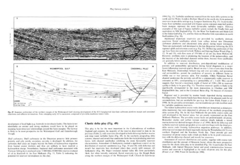
          Fig.  47.  Sequence architecture of  the  northern margin of  the  Widmerpool Gulf  showing development of  the  EC6  hanging-wall dip-slope carbonate  platform margin and  associated  delta  systems  (Fig.  50).  In  the  East  Midlands  the  pro-delta  source  rocks  are
          clinoforms  and  reflector terminations. Note  onlapping early LC1 a  succession, composed  of pro-delta  mudstone source  rocks.
                                                                                                                                                               well  developed  in  the  basinal  areas,  but  are  poorly  represented  on  the  East
                                                                                                                                                               Midlands  Platform. The  pro-delta  source  facies are  predominantly  oil prone.
                                                                                                                                                               Biomarker  studies  and  carbon  isotope  analyses  clearly  indicate  a  mixed
                                                                                                                                                                                                                               and
          development of local highs (e.g. footwalls to intrabasin faults). The fades  is not  Clastic  delta  play (Fig.  49)                                 marine/terrestrial  derived  kerogen  (Fraser  et al.  1990). Both  the delta-top  pro-
                                                                                                                                                                                               across and interfinger with the distal
                                                                                                                                                               turbidite reservoir systems prograded
          identifiable  on  seismic  and  strong  emphasis  would  have  to  be  placed  on                                                                    delta  source  rocks  forming  hydrocarbon  migration  pathways.  In  addition,
          mapping facies-structural  relationships around  the basin margins. The fairway  This  play  is  by  far  the  most  important  in  the  Carboniferous  of  northern  delta-top coal swamps developed  regionally during the Westphalian (LC2)  over
          is  likely  to  be  most  prospective  in  the  Widmerpool  Gulf  and  Gainsborough  England  and  contains  the  majority  of  the  reserves  discovered  to  date  in  the  northern  England  and  the  Southern  North  Sea.  These  provide  gas  and
          Trough.                                                                   province (Table  2), with reservoirs developed  in both  delta-top/shallow marine  occasional  oil prone  source  rocks  which  are  likely  to  be  in  good communica-
                                                                                    and  deep  water  turbidite  facies  (Fig.  49).  In  the  southerly  prograding  delta  tion  with the  delta-top  channel and  mouth  bar  reservoirs.
          Shelf  carbonates.  Shelf  carbonates  in  the  Dinantian  preserve  little  primary  systems, channel and mouth bar  sandstones form the main producing reservoir  Assessment  of  reservoir distribution and  quality, together  with  source  rock
          porosity  and  only  patchy  secondary  porosity  is  developed.  In  addition,  the  facies,  with  channel  sandbodies  exhibiting  the  more  favourable  reservoir  distribution  and  the  amount  of  Mesozoic  burial, allows the  main  prospective
          carbonate  shelf areas  are  largely  beyond  the  limits of  hydrocarbon  migration  characteristics.  Antecedent  rift  bathymetry  exerted  a  significant control  on  the  areas  for  the  clastic delta play to  be identified  (Fig.  52). In particular  the  East
          from  basinal  source  kitchens  and  thus  are  unlikely  to  have  received  a  distribution  of  reservoir  sandstones  (e.g.  Figs.  34 and  38),  with delta-top  and  Midlands,  with  limited  Mesozoic  burial  and  good  communication  between
          hydrocarbon  charge.  Nevertheless,  fractured  shelf carbonates  associated  with  mouth  bar  reservoirs  best  developed  where  they  axially  infill  remnant  rift  source  and  reservoir  is  highlighted  as  the  main  oil-prone  area  for  this  play
          Variscan folding have produced  some  32 000 bbls (50 000 bbls reserves in place)  bathymetry  (Fig.  50).  Major  lowstand  incised  valley  fills  form  particularly  (Fraser  et  al.  1990; Fraser  & Gawthorpe  1990).
          of  oil  in  Hardstoft  in  the  East  Midlands  (Fig.  11;  Table  2)  indicating  the  thick,  but  often  laterally  restricted,  fluvial  reservoirs  (e.g.  the  Rough  Rock
          potential  for  reservoir development  in  this play.                     along  the  northern  margin  of  the  Widmerpool  Gulf;  Church  &  Gawthorpe
   71   72   73   74   75   76   77   78   79   80   81