
Page 249 - Build Your Own Quadcopter_ Power Up Your Designs with the Parallax Elev-8
P. 249
228 Bu il d Y o ur O w n Q u a d c o p t e r
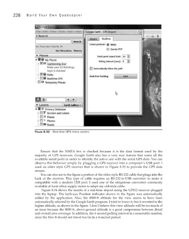
Figure 8.32 Real-time GPS menu screen.
Ensure that the NMEA box is checked because it is the data format used by the
majority of GPS receivers. Google Earth also has a very nice feature that scans all the
available serial ports in order to identify the active one with the serial GPS data. You can
observe this behavior simply by plugging a GPS receiver into a computer’s USB port. I
used an older style GPS receiver that is shown in Figure 8.33 to provide the GPS data
stream.
You can also see in the figure a portion of the older-style RS-232 cable that plugs into the
back of the receiver. This type of cable requires an RS-232-to-USB converter to make it
compatible with a modern USB port. I used one of the ubiquitous converters commonly
available at local office supply stores to adapt my old-style cable.
Figure 8.34 shows the results of a real-time import using the GPS12 receiver plugged
into the laptop. The bulls-eye Position indicator shown in the figure was automatically
added by the application. Also, the 8000-ft altitude for the view seems to have been
automatically selected by the Google Earth program. I tried to lower it, but it reverted to the
higher altitude, as shown in the figure. I don’t believe this view altitude will be too much of
an issue because the 8000-ft, above-ground altitude is a good compromise between detail
and overall area coverage. In addition, the 4-second polling interval is a reasonable number,
since the Elev-8 should not travel too far in a 4-second period.