
Page 296 - Caldera Volcanism Analysis, Modelling and Response
P. 296
A Review on Collapse Caldera Modelling 271
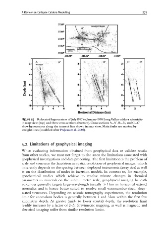
Figure 15 Relocated hypocenters of July 1997 to January 1998 LongValley caldera seismicity
in map view (top) and three cross sections (bottom). Cross sections A--Au,B--Bu,and C--Cu
show hypocentres along the transect line shown in map view. Main faults are marked by
straight lines (modi¢ed after Prejean et al., 2002).
4.2. Limitations of geophysical imaging
When evaluating information obtained from geophysical data to validate results
from other studies, we must not forget to also assess the limitations associated with
geophysical investigations and data processing. The first limitation is the problem of
scale and concerns the limitation in spatial resolution of geophysical images, which
inherently depends on the spacing between deployed instruments (array size) as well
as on the distribution of nodes in inversion models. In contrast to, for example,
geochemical studies which achieve to resolve minute changes in chemical
parameters in minerals on the submillimetre scale, geophysical imaging beneath
volcanoes generally targets large-wavelength (usually c1 km in horizontal extent)
anomalies and is hence better suited to resolve small wavenumber-sized, deep-
seated structures. Depending on seismic tomography experiments, the resolution
limit for anomalous bodies is generally between 1 and 3 km within the first few
kilometres depth. At greater (mid- to lower crustal) depth, the resolution limit
readily increases by a factor of 2–3. Gravimetric mapping, as well as magnetic and
electrical imaging suffer from similar resolution limits.