
Page 350 - Carbonate Facies in Geologic History
P. 350
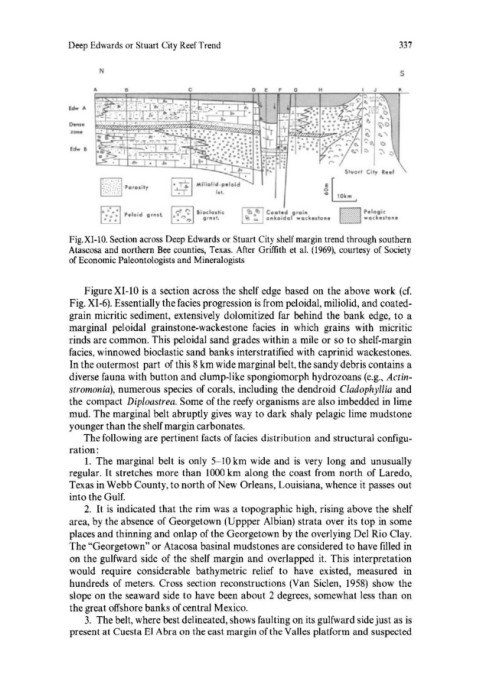
Deep Edwards or Stuart City Reef Trend                            337

                     N                                                           s

                                                    o  E    G    H               I<
               EcIw  "
               . ...,.
               Den"
               EcIw  I

                                                                      $t"ort  City  R •• f
                     b:.:::J Poro.it1                             ~b
                      "·
                      • 0-.  '.Ioid"  trn.t  1-: ';' I';oclo,,;<
                     D . . ,        •• ""'r.'Io   iII,rut .
               Fig. XI -10. Section across Deep Edwards or Stuart City shelf margin trend through southern
               Atascosa and northern Bee counties, Texas. After  Griffith  et al.  (1969),  courtesy of Society
               of Economic Paleontologists and Mineralogists


                  Figure XI-lO is  a section across the shelf edge  based  on the above  work (cf.
               Fig. XI-6). Essentially the facies progression is from peloidal, miliolid, and coated-
               grain micritic sediment, extensively  dolomitized  far  behind  the  bank edge,  to a
               marginal  peloidal  grainstone-wackestone  facies  in  which  grains  with  micritic
               rinds are common. This peloidal sand grades within a mile or so to shelf-margin
               facies, winnowed bioclastic sand banks interstratified with caprinid wackestones.
               In the outermost  part  of this 8 km wide marginal belt, the sandy debris contains a
               diverse fauna with button and clump-like spongiomorph hydrozoans (e.g.,  Actin-
               stromonia), numerous species  of corals, including the dendroid Cladophyllia  and
               the compact  Diploastrea. Some of the reefy organisms are also imbedded in lime
               mud. The marginal belt abruptly gives way  to dark shaly pelagic lime mudstone
               younger than the shelf margin carbonates.
                  The following are pertinent facts of facies  distribution  and structural configu-
               ration:
                  1.  The  marginal  belt  is  only  5- 10 km wide  and is  very  long  and  unusually
               regular. It stretches more than  1000 km along the coast from  north  of Laredo,
               Texas in Webb County, to north of New Orleans, Louisiana, whence it passes out
               into the Gulf.
                  2.  It is  indicated that the rim was a  topographic high, rising above the shelf
               area, by the absence of Georgetown (Uppper Albian) strata over its top in some
               places and thinning and onlap of the Georgetown by the overlying Del Rio Clay.
               The "Georgetown" or Atacosa basinal mudstones are considered to have filled  in
               on the gulfward side  of the shelf margin  and overlapped  it.  This  interpretation
               would  require  considerable  bathymetric  relief  to  have  existed,  measured  in
               hundreds  of meters.  Cross  section  reconstructions (Van  Siclen,  1958)  show  the
               slope on the seaward side to have been about 2 degrees, somewhat less than on
               the great offshore banks of central Mexico.
                  3.  The belt, where best delineated, shows faulting on its gulfward side just as is
               present at Cuesta EI Abra on the east margin of the Valles platform and suspected