
Page 354 - Carbonate Facies in Geologic History
P. 354
Stratigraphy and Tectonic Framework 341
mot'~ "'. ",Ietitlc Itt.
,torv.d euainic bOlin
m Sh.1f lime.ton.
S
~ micritic I.t with
l
h
oo
t::f:::::I:j lome rudll'l
~ IEGltwaul li Mit
Early
~ C,.loceoUl thol.
ARAIIAN SHiElD
UPPER THA,..,A,..,A AND lOWER
WASIA fACIES AND THICKNESS
Omo" Gulf
Of EARLY ,..,IDDl E CRETACEOUS
o 200 400km
.L...
1 .... ___ __ ---",
I
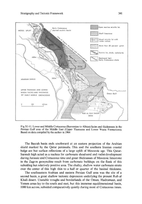
Fig.XI-l1. Lower and Middle Cretaceous (Barremian to Albian) facies and thicknesses in the
Persian Gulf area of the Middle East (Upper Thamama and Lower Wasia Formations).
Based on data compiled by the author in 1964
The Basrah basin ends southward at an eastern projection of the Arabian
shield marked by the Qatar peninsula. This and the southern Iranian coastal
bulge are but surface reflections of a large uplift of Mesozoic age. This Qatar-
Surmeh high acted as a nucleus for carbonate shoal sand and rudist development
during Jurassic and Cretaceous time and great thicknesses of Mesozoic limestone
in the Zagros geosyncline result from carbonate buildups on the flank of this
subsiding but relatively positive area. The chalky, shallow water carbonate strata
over the center of this high thin to a half or quarter of the basinal thickness.
The southeastern Arabian and eastern Persian Gulf area was the site of a
second basin, a great shallow tectonic depression underlying the present Rub al
Khali desert. Unstable troughs and borderlands of the Oman, Hadramaut, and
Yemen areas lay to the south and east, but this immense equidimensional basin,
1000 km across, subsided comparatively quietly during most of Cretaceous times.