
Page 256 - Carbonate Platforms Facies, Sequences, and Evolution
P. 256
a
tary
high,
ments
flysch.
cipally
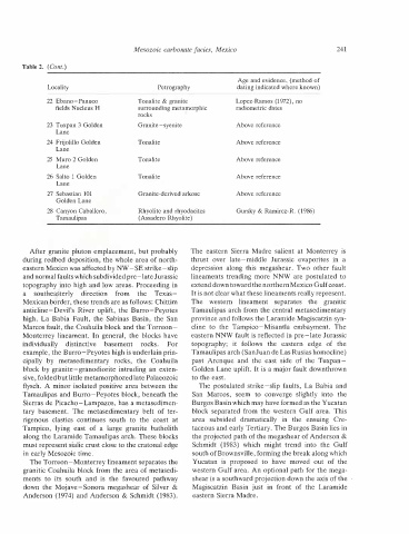
Table 2.
rigenous
Tampico,
to
28
24
by
individually
its
(Cont.)
basement.
Locality
Lane
Lane
Lane
Lane
lying
La Babia
southea.sterly
clastics
south
The
east
Tamaulipas
Monterrey lineament.
Fault,
Golden Lane
27 Sebastian 101
in early Mesozoic time.
26 Saito 1 Golden
of
and
distinctive
22 Ebano-Panuco
25 Muro 2 Golden
fields Nucleus H
Frijolillo Golden
23 Tuxpan 3 Golden
a
down the Mojave-Sonora
is
Canyon Caballero,
continues
direction
metasedimentary
anticline-Devil's River uplift,
the
large
In general,
south
Anderson (1974) and Anderson &
from
rocks,
basement
to
and normal faults which subdivided pre
megashear
metasedimentary
the
the
granite
of
the
favoured
the Sabinas Basin,
rocks
belt
rocks.
Tonalite
Tonalite
Tonalite
Mesozoic
of
coast
Silver
Texas
Marcos fault, the Coahuila block and the Torreon
granitic Coahuila block from the area of metasedi
block by granite-granodiorite intruding an exten
example, the Burro-Peyotes high is underlain prin
during redbed deposition, the whole area of north
Sierras de Picacho-Lampazos, has a metasedimen
ter
the blocks have
Coahuila
A minor isolated positive area between the
-late Jurassic
eastern Mexico was affected by NW-SE strike-slip
topography into high and low areas. Proceeding in
batholith
&
Schmidt (1983).
After granite pluton emplacement, but probably
must represent sialic crust close to the cratonal edge
Mexican border, these trends are as follows: Chittim
the Burro-Peyotes
the San
sive, folded but little metamorphozed late Palaeozoic
Tamaulipas and Burro-Peyotes block, beneath the
For
pathway
The Torreon-Monterrey lineament separates the
along the Laramide Tamaulipas arch. These blocks
at
Granite-syenite
Tonalite & granite
Petrography
(Assadero Rhyolite)
carbonate
Granite-derived arkose
The
The
San
past
area
Rhyolite and rhyodacites
cline
surrounding metamorphic
thrust
The
to
Schmidt
Yucatan
depression
to the east.
over
is
topography;
Magiscatzin
the
Marcos,
western
Arenque
subsided
it
facies, Mexico
(1983)
along
and
Basin
eastern Sierra
seem
this
proposed
eastern Sierra Madre.
which
to
the
follows
just
late-middle
to
lineament
Madre
in
dramatically
the
east
Above reference
Above reference
Above reference
Above reference
Above reference
might
radiometric dates
have
in
Tampico-Misantla
front
side
converge
megashear.
salient
Jurassic
of
trend
of
postulated strike-slip faults,
Lopez-Ramos (1972), no
separates
the
at
eastern
Two
moved
Gursky & Ramirez-R. (1986)
the
the
into
the
slightly
--------------------------------------------------------------
Age and evidence, (method of
dating indicated where known)
edge
out
evaporites
ensuing
the
block separated from the western Gulf area.
embayment.
of
into
of
Monterrey
in
Tuxpan
province and follows the Laramide Magiscatzin syn
extend down toward the northern Mexico Gulf coast.
It is not clear what these lineaments really represent.
Cre
other fault
western Gulf area. An optional path for the mega
is
a
Tamaulipas arch (SanJuan de Las Rusias homocline)
the
the projected path of the megashear of Anderson &
Golden Lane uplift. It is a major fault downthrown
eastern NNW fault is reflected in pre-late Jurassic
granitic
lineaments trending more NNW are postulated to
The
Tamaulipas arch from the central metasedimentary
Gulf
south of Brownsville, forming the break along which
241
the
the
La Babia and
Burgos Basin which may have formed as the Yucatan
taceous and early Tertiary. The Burgos Basin lies in
This
Laramide
shear is a southward projection down the axis of the