
Page 289 - Carbonate Platforms Facies, Sequences, and Evolution
P. 289
a
::
u,IV
and
270
ssw
Ordej6n
region
G
region,
Pujalte,
Fig. 22.
Pujalte,
suggests
o
: High
Recent
Km
a
Mondejar,
D Carbonates
ul sequence
units in the
·.
referred
used
organization,
1981).
1975).
because
to
as
1979)
formities present
area
----
studies
D Terrigenous materials
In
(Garcfa-Mondejar
An
as
based
lower terrigenous
in
of
�II,Y : Low subsidence areas
subsidence areas
angular unconformity,
(Fig.
&
the
limits
of the
have
on
transgressive
the
unit,
of
EBRO
\.,u:·_-�
rest
example
Arija
Valnera
ous or marine carbonate unit.
traced
" "fl E'ir'l
been identified as an erosional
21). The
episode
presence
depositional
Pujalte,
:/<.'/
of the
the
in places
Ill
unconformity
sequences,
c!'f:o
southwestern
Pto.del Escudo
of two
:_
is
1977;
<::_-_:·
followed
region
sequences
part
�
J.
the
surfaces
in
shown
IV
by a re
and continental, and an upper fine-grained terrigen
of some of the uncon
cor
Garcfa
boundary
alternations of terrigenous and carbonate formations
and
gressive one. The top regressive parts of the cycles
are locally marked by significant erosional surfaces.
The complete cycle
age. It is best established in the western part of the
The first Urgonian sequence, U1, is of early Aptian
cyclicity has been
sense of Mitchum et al. (1977), (Garcfa-Mondejar &
between two distinct fluvial
sediments or between marine and fluvial sediments
(Garcfa-Mondejar &
unconformities
the Lower Aptian transgressive deposits. The upper
attributed to repeated tectonic pulses in the basin
the
conglomeratic
of the
unconformities, locally angular. The lower limit has
in
and their correlative conformities over much of the
Basque-Cantabrian region, and four main cycles or
depositional sequences have been identified (U1 to
relative conformity is considered to be the base of
part of the region, either between fluvial and fluvial
U4, Fig. 23). Each sequence is normally made up of
surface, locally an
limit is an angular unconformity in the southwestern
VALNERA
Rio As6n
the
The
able
sharp
places
logies,
ditions
marine
arating
Garcfa-Mondejar
between
different
localized
has been
erosional
deposited
North
Metre-scale
second
u2 sequence
proximately
in
breaks
in
disconformity
where
Ajo
with
NNE
��
at
places
boundary
in
shallow
the
the
Vizcaya
by
sandstones,
joints,
cavities
the
deeper
shallow-water
sequence,
(top of U1 in Fig. 22).
an
showing
taken from the
in the
of
are
base
& Garcfa-Pascual, 1982).
dark
suggested by their
platform
U2,
rest
water
palaeochannel
filled
paleokarst
central
of
angular
of the
platform
is
than
Mondejar (1979).
the
Anticlinorium,
stone breccias) in a nearby outcrop.
dissolution
with
part
palaeokarst
mudstones
sedimentation.
limestones
constituent
is
in
the
or
better
predominantly filled with
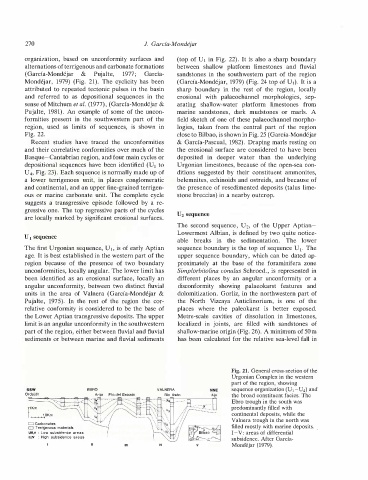
subsidence. After Garcfa
I-V: areas of differential
region,
one
of the
and
The
part of the region, showing
limestones
foraminifera
unconformity
morphologies,
features
Ebro trough in the south was
sequence boundary is the top of sequence U 1.
of
continental deposits, while the
marls.
sandstones
Valnera trough in the north was
or
the broad constituent facies. The
Urgonian Complex in the western
filled mostly with marine deposits.
field sketch of one of these palaeochannel morpho
sep
of the Upper Aptian
the presence of resedimented deposits (talus lime
Urgonian limestones, because of the open-sea con
upper sequence boundary, which can be dated ap
Lowermost Albian, is defined by two quite notice
from
A
fluvial
It is also a sharp boundary
sandstones in the southwestern part of the region
The
limestones,
Draping marls resting on
the erosional surface are considered to have been
and
exposed.
region
close to Bilbao, is shown in Fig. 25 (Garcfa-Mondejar
the
underlying
shallow-marine origin (Fig. 26). A minimum of 50 m
locally
(Garcfa-Mondejar, 1979) (Fig. 24 top of U1). It is a
zone
ammonites,
lower
Simplorbitolina conulus Schroed., is represented in
a
belemnites, echinoids and ostreids, and because of
of
dolomitization. Gorliz, in the northwestern part of
sequence organization (U 1-U4) and
Fig. 21. General cross-section of the
calculated for the relative sea-level fall in