
Page 348 - Civil Engineering Formulas
P. 348
HIGHWAY AND ROAD FORMULAS 279
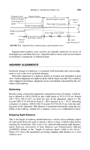
Normal crown Tangent runout L s
Point of change Runoff length of spiral Start of
from tangent to T.S. curve
spiral Outer edge of pavement
Grade at C pavement
L
E
Grade at pavement
edges Inner edge of pavement
A B C D E
C L Profile control
Normal Full
crown superelevation E
FIGURE 11.4 Superelevation variations along a spiral transition curve.
Superelevated roadway cross sections are typically employed on curves of
rural highways and urban freeways. Superelevation is rarely used on local streets
in residential, commercial, or industrial areas.
HIGHWAY ALIGNMENTS
Geometric design of a highway is concerned with horizontal and vertical align-
ment as well as the cross-sectional elements.
Horizontal alignment of a highway defines its location and orientation in plan
view. Vertical alignment of a highway deals with its shape in profile. For a roadway
with contiguous travel lanes, alignment can be conveniently represented by the cen-
terline of the roadway.
Stationing
Distance along a horizontal alignment is measured in terms of stations. A full sta-
tion is defined as 100 ft (30.48 m) and a half station as 50 ft (15.24 m). Station
100 50 is 150 ft (45.7 m) from the start of the alignment, station 0 00.
A point 1492.27 ft (454.84 m) from 0 00 is denoted as 14 92.27, indicating
a location 14 stations, 1400 ft (426.72 m) plus 92.27 ft (28.12 m), from the start-
ing point of the alignment. This distance is measured horizontally along the cen-
terline of the roadway, whether it is a tangent, a curve, or a combination of these.
Stopping Sight Distance
This is the length of roadway needed between a vehicle and an arbitrary object
(at some point down the road) to permit a driver to stop a vehicle safely before
reaching the obstruction. This is not to be confused with passing sight distance,
which American Association of State Highway and Transportation Officials
(AASHTO) defines as the “length of roadway ahead visible to the driver.”
Figure 11.5 shows the parameters governing stopping sight distance on a crest
vertical curve.