
Page 87 - Design of Solar Thermal Power Plants
P. 87
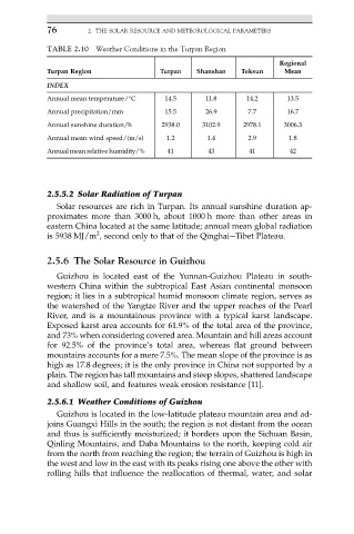
76        2. THE SOLAR RESOURCE AND METEOROLOGICAL PARAMETERS

            TABLE 2.10 Weather Conditions in the Turpan Region
                                                                     Regional
            Turpan Region               Turpan   Shanshan   Toksun    Mean
            INDEX
            Annual mean temperature/ C   14.5      11.8      14.2      13.5

            Annual precipitation/mm      15.5      26.9      7.7       16.7
            Annual sunshine duration/h  2938.0    3102.9    2978.1    3006.3
            Annual mean wind speed/(m/s)  1.2      1.4       2.9       1.8
            Annual mean relative humidity/%  41     43        41        42


            2.5.5.2 Solar Radiation of Turpan
               Solar resources are rich in Turpan. Its annual sunshine duration ap-
            proximates more than 3000 h, about 1000 h more than other areas in
            eastern China located at the same latitude; annual mean global radiation
                         2
            is 5938 MJ/m , second only to that of the QinghaieTibet Plateau.

            2.5.6 The Solar Resource in Guizhou
               Guizhou is located east of the Yunnan-Guizhou Plateau in south-
            western China within the subtropical East Asian continental monsoon
            region; it lies in a subtropical humid monsoon climate region, serves as
            the watershed of the Yangtze River and the upper reaches of the Pearl
            River, and is a mountainous province with a typical karst landscape.
            Exposed karst area accounts for 61.9% of the total area of the province,
            and 73% when considering covered area. Mountain and hill areas account
            for 92.5% of the province’s total area, whereas flat ground between
            mountains accounts for a mere 7.5%. The mean slope of the province is as
            high as 17.8 degrees; it is the only province in China not supported by a
            plain. The region has tall mountains and steep slopes, shattered landscape
            and shallow soil, and features weak erosion resistance [11].
            2.5.6.1 Weather Conditions of Guizhou
               Guizhou is located in the low-latitude plateau mountain area and ad-
            joins Guangxi Hills in the south; the region is not distant from the ocean
            and thus is sufficiently moisturized; it borders upon the Sichuan Basin,
            Qinling Mountains, and Daba Mountains to the north, keeping cold air
            from the north from reaching the region; the terrain of Guizhou is high in
            the west and low in the east with its peaks rising one above the other with
            rolling hills that influence the reallocation of thermal, water, and solar