
Page 86 - Earth's Climate Past and Future
P. 86
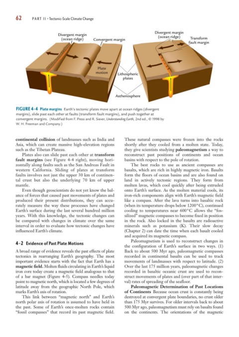
62      PART II • Tectonic-Scale Climate Change


                                                                          Divergent margin
                            Divergent margin                                (ocean ridge)
                              (ocean ridge)  Convergent margin                             Transform
                                                                                          fault margin


                                               Plate
                                              motion
                                                         Lithospheric
                                                           plates


                                                        Asthenosphere


        FIGURE 4-4 Plate margins Earth’s tectonic plates move apart at ocean ridges (divergent
        margins), slide past each other at faults (transform fault margins), and push together at
        convergent margins. (Modified from F. Press and R. Siever, Understanding Earth, 2nd ed., © 1998 by
        W. H. Freeman and Company.)


        continental collision of landmasses such as India and  These natural compasses were frozen into the rocks
        Asia, which can create massive high-elevation regions  shortly after they cooled from a molten state. Today,
        such as the Tibetan Plateau.                        they give scientists studying paleomagnetism a way to
           Plates also can slide past each other at transform  reconstruct past positions of continents and ocean
        fault margins (see Figure 4-4 right), moving hori-  basins with respect to the pole of rotation.
        zontally along faults such as the San Andreas Fault in  The best rocks to use as ancient compasses are
        western California. Sliding of plates at transform  basalts, which are rich in highly magnetic iron. Basalts
        faults involves not just the upper 30 km of continen-  form the floors of ocean basins and are also found on
        tal crust but also the underlying 70 km of upper    land in actively tectonic regions. They form from
        mantle.                                             molten lavas, which cool quickly after being extruded
           Even though geoscientists do not yet know the bal-  onto Earth’s surface. As the molten material cools, its
        ance of forces that caused past movements of plates and  iron-rich components align with Earth’s magnetic field
        produced their present distributions, they can accu-  like a compass. After the lava turns into basaltic rock
        rately measure the way these processes have changed  (when its temperature drops below 1200°C), continued
        Earth’s surface during the last several hundred million  cooling to temperatures near 600°C allows the “fos-
        years. With this knowledge, the tectonic changes can   silized” magnetic compasses to become fixed in position
        be compared with changes in climate over the same   in the rock. Also locked in the basalts are radioactive
        interval in order to evaluate how tectonic changes have  minerals such as potassium (K). Their slow decay
        influenced Earth’s climate.                         (Chapter 2) can date the time when each basalt cooled
                                                            and acquired its magnetic compass.
                                                               Paleomagnetism is used to reconstruct changes in
        4-2 Evidence of Past Plate Motions
                                                            the configuration of Earth’s surface in two ways. (1)
        A broad range of evidence reveals the past effects of plate  Back to about 500 Myr ago, paleomagnetic compasses
        tectonics in rearranging Earth’s geography. The most  recorded in continental basalts can be used to track
        important evidence starts with the fact that Earth has a  movements of landmasses with respect to latitude. (2)
        magnetic field. Molten fluids circulating in Earth’s liquid  Over the last 175 million years, paleomagnetic changes
        iron core today create a magnetic field analogous to that  recorded in basaltic oceanic crust are used to recon-
        of a bar magnet (Figure 4-5). Compass needles today  struct movements of plates and (over part of that inter-
        point to magnetic north, which is located a few degrees of  val) rates of spreading of the seafloor.
        latitude away from the geographic North Pole, which    Paleomagnetic Determination of Past Locations
        marks Earth’s axis of rotation.                     of Continents Because ocean crust is constantly being
           This link between “magnetic north” and Earth’s   destroyed at convergent plate boundaries, no crust older
        north polar axis of rotation is assumed to have held in  than 175 Myr survives. For older intervals back to about
        the past. Some of Earth’s once-molten rocks contain  500 Myr ago, paleomagnetism must rely on basalts found
        “fossil compasses” that record its past magnetic field.  on the continents. The orientations of the magnetic