
Page 87 - Earth's Climate Past and Future
P. 87
CHAPTER 4 • Plate Tectonics and Long-Term Climate 63
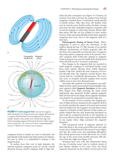
tudes has that orientation (see Figure 4-5 bottom). In
contrast, lavas that cool near the equator have internal
compasses oriented closer to horizontal, nearly parallel
to Earth’s surface. After they form, the basaltic rocks
may be carried across Earth’s surface by plate tectonic
processes, but their embedded magnetic compasses still
record the latitude at which they formed. Rocks older
than about 500 Myr are less reliable for these studies
because of the increasing likelihood that their magnetic
compasses have been reset to the magnetic field of a
later time.
Paleomagnetic Dating of Ocean Crust Paleo-
magnetism is used to trace the movement of the
seafloor during the last 175 Myr because of an entirely
different characteristic of Earth’s magnetic field: the
A fact that it has repeatedly reversed direction. Compasses
that today point to magnetic north in the present “nor-
Geographic Magnetic mal” magnetic field would have pointed to magnetic
North Pole north south (a position very near the South Pole) during times
when the field was in a “reversed” orientation.
Past changes in the magnetic field are recorded in
fossil magnetic compasses in well-dated basaltic rocks
from many regions. Because these widely dispersed
basaltic rocks have yielded the same sequence of rever-
sals through time, the magnetic reversal history they
record must be a worldwide phenomenon. The rever-
sals occur at irregular intervals ranging from several
million years to just a few thousand years.
Soon after this magnetic reversal sequence was estab-
Equator lished on land, marine geoscientists found stripelike mag-
netic patterns called magnetic lineations on the ocean
floor (Figure 4-6). Ships surveying the ocean towed
instruments that measured Earth’s regional magnetic
field. On the mid-ocean ridges, these magnetic lineations
were found to be symmetrical around the ridge axis.
To the surprise of most scientists, the mapped pat-
tern of highs and lows measured in the magnetic field at
sea closely matched the pattern of normal and reversed
B intervals defined by the magnetic reversal history from
sequences of basalts on land. Because of this match, sci-
FIGURE 4-5 Earth’s magnetic field Like (A) the magnetic entists realized that the time framework developed on
field indicated by iron filings around a bar magnet, (B) Earth has land could be transferred directly to the lineations in
a magnetic field that determines the alignment of compass the ocean. Based on this link, ocean crust could be dated
needles. Basaltic rocks contain iron minerals that align with in any region where ships measured the magnetic
Earth’s prevailing magnetic field shortly after the molten magma lineations.
cools to solid rock. (B: F. Press and R. Siever, Understanding Earth,
This unexpected match of magnetic patterns on
2nd ed., © 1998 by W. H. Freeman and Company.)
land with those in the ocean proved that new (zero-age)
ocean crust is being formed at the crests of ocean ridges,
and that the ocean crust and underlying lithosphere
compasses frozen in basalts are used to determine the then slowly spread away in both directions. As a result,
past latitude of the basalt (and of the portion of continen- the age of the ocean crust steadily increases with dis-
tal crust in which it is embedded) in relation to the tance from the ridges (see Figure 4-6).
magnetic poles. Scientists have now used this information about
In molten lavas that cool at high latitudes, the the age of existing ocean crust to evaluate causes of
internal magnetic compasses point in a nearly vertical past climate changes in two ways. First, the dated
direction because Earth’s magnetic field at high lati- magnetic lineations on the seafloor can be used to roll