
Page 92 - Earth's Climate Past and Future
P. 92
68 PART II • Tectonic-Scale Climate Change
doubles the number of years the model simulates for
each hemisphere.
A second important decision on input to the model
is global sea level. Evidence from rocks on Pangaea
indicates that global sea level 200 Myr ago was compa-
rable to the level today. As a result, sea level was placed
close to the structural edges of the continents, where it
lies today.
A third important decision is the distribution of ele-
vated topography on the continents, and this aspect of
A Pangaea Pangaea is not as well known. In the simulation exam-
ined here, all land in the interior of Pangaea was repre-
sented as a low-elevation plateau at a uniform height of
1000 m, with its edges sloping gradually down to sea
level along the outer margins of the continents.
Another important boundary condition that needs
to be specified is the CO level in the atmosphere.
2
Unfortunately, the CO concentration for 200 Myr ago
2
is not directly known. Although long-term CO levels
2
are determined by tectonic factors, they are at the same
time an integral part of the climate system. Because the
choice of CO concentration will have a direct impact
2
B Pangaea in model grid on the climate simulated by the model, the danger of
circular reasoning is present.
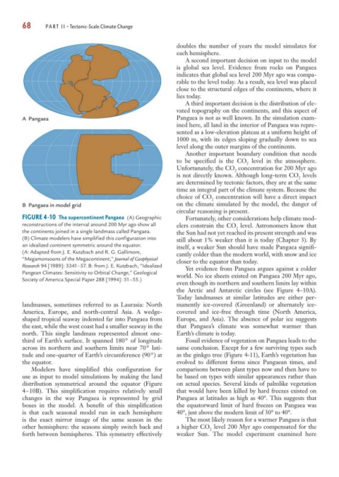
FIGURE 4-10 The supercontinent Pangaea (A) Geographic Fortunately, other considerations help climate mod-
reconstructions of the interval around 200 Myr ago show all elers constrain the CO level. Astronomers know that
2
the continents joined in a single landmass called Pangaea. the Sun had not yet reached its present strength and was
(B) Climate modelers have simplified this configuration into still about 1% weaker than it is today (Chapter 3). By
an idealized continent symmetric around the equator. itself, a weaker Sun should have made Pangaea signifi-
(A: Adapted from J. E. Kutzbach and R. G. Gallimore, cantly colder than the modern world, with snow and ice
“Megamonsoons of the Megacontinent,” Journal of Geophysical closer to the equator than today.
Research 94 [1989]: 3341–57. B: from J. E. Kutzbach, “Idealized Yet evidence from Pangaea argues against a colder
Pangean Climates: Sensitivity to Orbital Change,” Geological world. No ice sheets existed on Pangaea 200 Myr ago,
Society of America Special Paper 288 [1994]: 51–55.)
even though its northern and southern limits lay within
the Arctic and Antarctic circles (see Figure 4-10A).
Today landmasses at similar latitudes are either per-
landmasses, sometimes referred to as Laurasia: North manently ice-covered (Greenland) or alternately ice-
America, Europe, and north-central Asia. A wedge- covered and ice-free through time (North America,
shaped tropical seaway indented far into Pangaea from Europe, and Asia). The absence of polar ice suggests
the east, while the west coast had a smaller seaway in the that Pangaea’s climate was somewhat warmer than
north. This single landmass represented almost one- Earth’s climate is today.
third of Earth’s surface. It spanned 180° of longitude Fossil evidence of vegetation on Pangaea leads to the
across its northern and southern limits near 70° lati- same conclusion. Except for a few surviving types such
tude and one-quarter of Earth’s circumference (90°) at as the ginkgo tree (Figure 4-11), Earth’s vegetation has
the equator. evolved to different forms since Pangaean times, and
Modelers have simplified this configuration for comparisons between plant types now and then have to
use as input to model simulations by making the land be based on types with similar appearances rather than
distribution symmetrical around the equator (Figure on actual species. Several kinds of palmlike vegetation
4–10B). This simplification requires relatively small that would have been killed by hard freezes existed on
changes in the way Pangaea is represented by grid Pangaea at latitudes as high as 40°. This suggests that
boxes in the model. A benefit of this simplification the equatorward limit of hard freezes on Pangaea was
is that each seasonal model run in each hemisphere 40°, just above the modern limit of 30° to 40°.
is the exact mirror image of the same season in the The most likely reason for a warmer Pangaea is that
other hemisphere: the seasons simply switch back and a higher CO level 200 Myr ago compensated for the
2
forth between hemispheres. This symmetry effectively weaker Sun. The model experiment examined here