
Page 403 - Fair, Geyer, and Okun's Water and wastewater engineering : water supply and wastewater removal
P. 403
JWCL344_ch11_357-397.qxd 8/2/10 9:01 PM Page 363
11.3 Precipitation 363
of cyclonic disturbances over the North American continent as well as the rotary or cyclonic
motion of horizontal air currents converging at points of low pressure.
In the continuous planetary circulation of the atmosphere between equator and poles,
warm, moisture-laden, tropical air masses travel poleward, are cooled, and precipitate
their moisture along the way. Ultimately, they are transformed into cold, dry, polar air. A
return movement drives polar air masses toward the equator, and heavy precipitation
results when tropical and polar air masses collide. The light, warm, tropical air cools and
precipitates its moisture as it is forced up and over the heavy polar air. Collisions between
tropical and polar air masses normally account for the protracted general rainfalls and
accompanying floods of the central and eastern United States. When, for unknown rea-
sons, polar air does not return toward the equator in the usual manner, serious droughts
can occur.
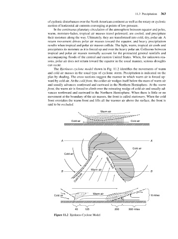
The Bjerkness cyclone model shown in Fig. 11.2 identifies the movements of warm
and cold air masses in the usual type of cyclonic storm. Precipitation is indicated on the
plan by shading. The cross-sections suggest the manner in which warm air is forced up-
ward by cold air. At the cold front, the colder air wedges itself below the mass of warm air
and usually advances southward and eastward in the Northern Hemisphere. At the warm
front, the warm air is forced to climb over the retreating wedge of cold air and usually ad-
vances northward and eastward in the Northern Hemisphere. When there is little or no
movement at the boundary of the air masses, the front is called stationary. When the cold
front overtakes the warm front and lifts all the warmer air above the surface, the front is
said to be occluded.
Warm air
Cold air Cold air
A A
Cold air
Cold air
Warm air Warm front
B B
Cold front
Warm air
Cold air 6 miles
40 125 200 300 miles
Figure 11.2 Bjerkness Cyclone Model