
Page 405 - Fair, Geyer, and Okun's Water and wastewater engineering : water supply and wastewater removal
P. 405
JWCL344_ch11_357-397.qxd 8/2/10 9:01 PM Page 365
11.3 Precipitation 365
Screen or shield
Beveled
edge
Receiver Receiver
Tipping bucket
To recording Weighing
device tank
Collecting
tube
Recording
drum Scales
(a) Standard (b) Tipping-bucket (c) Weighing rain gage
rain gage rain gage
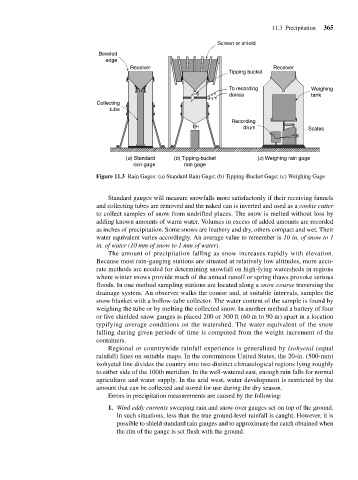
Figure 11.3 Rain Gages: (a) Standard Rain Gage; (b) Tipping-Bucket Gage; (c) Weighing Gage
Standard gauges will measure snowfalls more satisfactorily if their receiving funnels
and collecting tubes are removed and the naked can is inverted and used as a cookie cutter
to collect samples of snow from undrifted places. The snow is melted without loss by
adding known amounts of warm water. Volumes in excess of added amounts are recorded
as inches of precipitation. Some snows are feathery and dry, others compact and wet. Their
water equivalent varies accordingly. An average value to remember is 10 in. of snow to 1
in. of water (10 mm of snow to 1 mm of water).
The amount of precipitation falling as snow increases rapidly with elevation.
Because most rain-gauging stations are situated at relatively low altitudes, more accu-
rate methods are needed for determining snowfall on high-lying watersheds in regions
where winter snows provide much of the annual runoff or spring thaws provoke serious
floods. In one method sampling stations are located along a snow course traversing the
drainage system. An observer walks the course and, at suitable intervals, samples the
snow blanket with a hollow-tube collector. The water content of the sample is found by
weighing the tube or by melting the collected snow. In another method a battery of four
or five shielded snow gauges is placed 200 or 300 ft (60 m to 90 m) apart in a location
typifying average conditions on the watershed. The water equivalent of the snow
falling during given periods of time is computed from the weight increment of the
containers.
Regional or countrywide rainfall experience is generalized by isohyetal (equal
rainfall) lines on suitable maps. In the coterminous United States, the 20-in. (500-mm)
isohyetal line divides the country into two distinct climatological regions lying roughly
to either side of the 100th meridian. In the well-watered east, enough rain falls for normal
agriculture and water supply. In the arid west, water development is restricted by the
amount that can be collected and stored for use during the dry season.
Errors in precipitation measurements are caused by the following:
1. Wind eddy currents sweeping rain and snow over gauges set on top of the ground.
In such situations, less than the true ground-level rainfall is caught. However, it is
possible to shield standard rain gauges and to approximate the catch obtained when
the rim of the gauge is set flush with the ground.