
Page 134 - Fundamentals of Geomorphology
P. 134
SMALL-SCALE TECTONIC AND STRUCTURAL LANDFORMS 117
the ocean’s surface. The island was named after the giant of fire in Icelandic mythology. Surtsey is about 1.5 km
2
in diameter with an area of 2.8 km . Between 1967 and 1991, Surtsey subsided about 1.1 m (Moore et al. 1992),
probably because the volcanic material compacted, the sea-floor sediments under the volcano compacted, and possibly
because the lithosphere was pushed downwards by the weight of the volcano. Today, the highest point on Surtsey is
174 m above sea level.
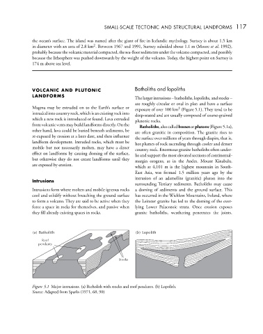
VOLCANIC AND PLUTONIC Batholiths and lopoliths
LANDFORMS The larger intrusions – batholiths, lopoliths, and stocks –
are roughly circular or oval in plan and have a surface
Magma may be extruded on to the Earth’s surface or exposure of over 100 km (Figure 5.1). They tend to be
2
intruded into country rock, which is an existing rock into deep-seated and are usually composed of coarse-grained
which a new rock is introduced or found. Lava extruded plutonic rocks.
from volcanic vents may build landforms directly. On the Batholiths,alsocalledbossesorplutons(Figure5.1a),
other hand, lava could be buried beneath sediments, be are often granitic in composition. The granite rises to
re-exposed by erosion at a later date, and then influence the surface over millions of years through diapirs, that is,
landform development. Intruded rocks, which must be hot plumes of rock ascending through cooler and denser
mobile but not necessarily molten, may have a direct country rock. Enormous granite batholiths often under-
effect on landforms by causing doming of the surface, lie and support the most elevated sections of continental-
but otherwise they do not create landforms until they margin orogens, as in the Andes. Mount Kinabalu,
are exposed by erosion. which at 4,101 m is the highest mountain in South-
East Asia, was formed 1.5 million years ago by the
Intrusions intrusion of an adamellite (granitic) pluton into the
surrounding Tertiary sediments. Batholiths may cause
Intrusions form where molten and mobile igneous rocks a doming of sediments and the ground surface. This
cool and solidify without breaching the ground surface has occurred in the Wicklow Mountains, Ireland, where
to form a volcano. They are said to be active when they the Leinster granite has led to the doming of the over-
force a space in rocks for themselves, and passive when lying Lower Palaeozoic strata. Once erosion exposes
they fill already existing spaces in rocks. granite batholiths, weathering penetrates the joints.
() Batholith ( ) Lopolith
b
a
Roof
pendants
Stocks
Figure 5.1 Major intrusions. (a) Batholith with stocks and roof pendants. (b) Lopolith.
Source: Adapted from Sparks (1971, 68, 90)