
Page 136 - Fundamentals of Geomorphology
P. 136
SMALL-SCALE TECTONIC AND STRUCTURAL LANDFORMS 119
may cut across the grain of the relief. The Great Dyke may form escarpments or ledges in plateau regions and
of Zimbabwe is over 500 km long and averages 6–8 km encourage waterfalls where they cut across river courses.
wide. On occasions, dykes radiate out from a central sup- In addition, their jointing may add a distinctive feature to
ply point to form cone sheets (Figure 5.2b). Necks and the relief, as in the quartz-dolerite Whin Sill of northern
pipes are the cylindrical feeders of volcanoes and appear England, which was intruded into Carboniferous sedi-
to occur in a zone close to the ground surface. They are ments. Inland, the Whin Sill causes waterfalls on some
more common in acid igneous rocks than in basalts.They streams and in places is a prominent topographic feature,
may represent the last stage of what was mainly a dyke as where Hadrian’s Wall sits upon it (Plate 5.2). Near the
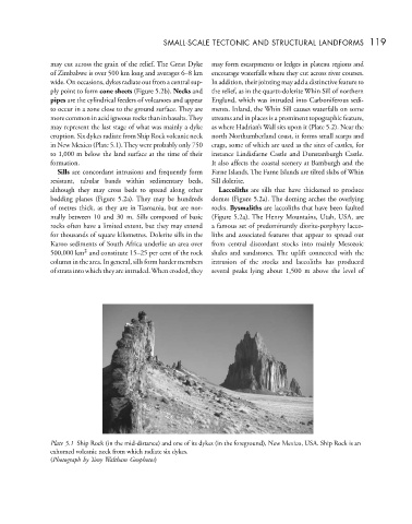
eruption. Six dykes radiate from Ship Rock volcanic neck north Northumberland coast, it forms small scarps and
in New Mexico (Plate 5.1).They were probably only 750 crags, some of which are used as the sites of castles, for
to 1,000 m below the land surface at the time of their instance Lindisfarne Castle and Dunstanburgh Castle.
formation. It also affects the coastal scenery at Bamburgh and the
Sills are concordant intrusions and frequently form Farne Islands. The Farne Islands are tilted slabs of Whin
resistant, tabular bands within sedimentary beds, Sill dolerite.
although they may cross beds to spread along other Laccoliths are sills that have thickened to produce
bedding planes (Figure 5.2a). They may be hundreds domes (Figure 5.2a). The doming arches the overlying
of metres thick, as they are in Tasmania, but are nor- rocks. Bysmaliths are laccoliths that have been faulted
mally between 10 and 30 m. Sills composed of basic (Figure 5.2a). The Henry Mountains, Utah, USA, are
rocks often have a limited extent, but they may extend a famous set of predominantly diorite-porphyry lacco-
for thousands of square kilometres. Dolerite sills in the liths and associated features that appear to spread out
Karoo sediments of South Africa underlie an area over from central discordant stocks into mainly Mesozoic
2
500,000 km and constitute 15–25 per cent of the rock shales and sandstones. The uplift connected with the
column in the area. In general, sills form harder members intrusion of the stocks and laccoliths has produced
of strata into which they are intruded.When eroded, they several peaks lying about 1,500 m above the level of
Plate 5.1 Ship Rock (in the mid-distance) and one of its dykes (in the foreground), New Mexico, USA. Ship Rock is an
exhumed volcanic neck from which radiate six dykes.
(Photograph by Tony Waltham Geophotos)