
Page 220 - Fundamentals of Geomorphology
P. 220
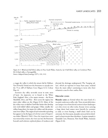
KARST LANDSCAPES 203


                     ()
                      a
               Altitude
                (m)
                                                  Normal streamsink
                         Partly vegetated channel
                1,250      taking flood water                     Perennial watercourse
                                                      Half-blind valley
                                             1,228 m  1,224 m
                1,225
                                                                    Stream in swamp
                      0                  100 m
                1,200
                     ()
                      b
                1,075
                                               Plateau surface
                          Doline       Doline         Blind valley         Stream in
                1,050                                                       swamp
                                           The Bath
                                           The Bath
                                           House                  contact
                                           House
                1,025                                        position
                                            Cave
                                            Cave                limestone–
                                                             Approx.  porphyry
                1,000                                           of
                      0                  100 m
                 975
              Figure 8.11 Blind and half-blind valleys in New South Wales, Australia. (a) A half-blind valley on Cooleman Plain.
              (b) A blind valley at Yarrangobilly.
              Source: Adapted from Jennings (1971, 110, 111)


              a craggy dry valley in which the stream fed by Malham  diverted the drainage underground. The ‘hanging val-
              Tarn formerly flowed over the limestone to cascade over  leys’, which are reported in many karst areas, resulted
              the 75-m cliff of Malham Cove (Figure 8.12; Colour  from the main valleys’ continuing to incise after their
              Plate 4).                                 tributaries ceased to have surface flow.
                Extensive dry valley networks occur in some areas
              of karst. An impressive set is found in the White  Meander caves
              Peak, England. Here, a few major streams – the Rivers
              Manifold, Dove, and Wye – flow across the region, but  Meander caves are formed where the outer bend of a
              most other valleys are dry (Figure 8.13). Many of the  meander undercuts a valley-side. Now, stream debris does
              dry valleys start as shallow, bowl-like basins that develop  not hamper rivers from lateral erosion in karst landscapes
              into rock-walled valleys and gorges. Other, smaller dry  as it does rivers on other rocks, because rivers carrying
              valleys hang above the major dry valleys and the perma-  a large clastic load cannot move laterally by corrasion
              nent river valleys.The origin of such networks is puzzling  as easily as rivers bearing a small clastic load can by
              but appears to be the legacy of a former cover of impervi-  corrosion. For this reason, meander caves are better devel-
              ous shales (Warwick 1964). Once the impervious cover  oped in karst terrain than elsewhere. A prime example is
              was removed by erosion, the rivers cut into the limestone  Verandah Cave, Borenore, New South Wales, Australia
              beneath until solution exploited planes of weakness and  (Figure 8.14).